You are here: Home > Network List > TA - USArray Transportable Network (new EarthScope stations) Stations List
> Station O02D Mt. Diablo Meridian, CA, USA > Earthquake Result Viewer
O02D Mt. Diablo Meridian, CA, USA - Earthquake Result Viewer
| Earthquake location: |
Santiago Del Estero Prov., Arg. |
| Earthquake latitude/longitude: |
-26.8/-63.1 |
| Earthquake time(UTC): |
2011/01/01 (001) 09:56:58 GMT |
| Earthquake Depth: |
577 km |
| Earthquake Magnitude: |
6.8 MB, 7.0 MW, 7.0 MW |
| Earthquake Catalog/Contributor: |
WHDF/NEIC |
|
| Network: |
TA USArray Transportable Network (new EarthScope stations) |
| Station: |
O02D Mt. Diablo Meridian, CA, USA |
| Lat/Lon: |
40.18 N/122.79 W |
| Elevation: |
965 m |
|
| Distance: |
86.7 deg |
| Az: |
318.524 deg |
| Baz: |
129.412 deg |
| Ray Param: |
0.042215794 |
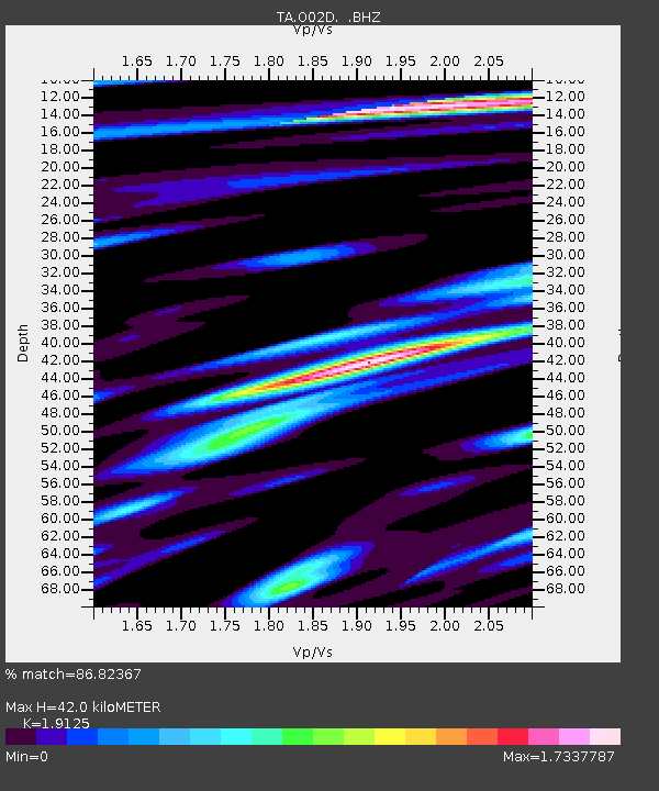
| Estimated Moho Depth: |
42.0 km |
| Estimated Crust Vp/Vs: |
1.91 |
| Assumed Crust Vp: |
6.566 km/s |
| Estimated Crust Vs: |
3.433 km/s |
| Estimated Crust Poisson's Ratio: |
0.31 |
|
| Radial Match: |
86.82367 % |
| Radial Bump: |
400 |
| Transverse Match: |
85.535286 % |
| Transverse Bump: |
400 |
| SOD ConfigId: |
346946 |
| Insert Time: |
2011-07-04 08:04:49.232 +0000 |
| GWidth: |
2.5 |
| Max Bumps: |
400 |
| Tol: |
0.001 |
|
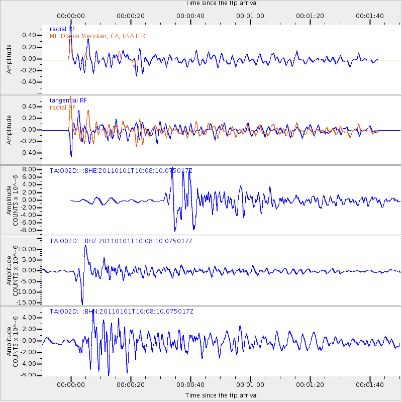
Signal To Noise
| Channel | StoN | STA | LTA |
| TA:O02D: :BHZ:20110101T10:08:10.075017Z | 18.207542 | 5.7046213E-6 | 3.133109E-7 |
| TA:O02D: :BHN:20110101T10:08:10.075017Z | 1.670096 | 7.751463E-7 | 4.6413277E-7 |
| TA:O02D: :BHE:20110101T10:08:10.075017Z | 7.9164696 | 3.2904393E-6 | 4.1564476E-7 |
| Arrivals |
| Ps | 6.0 SECOND |
| PpPs | 18 SECOND |
| PsPs/PpSs | 24 SECOND |


