You are here: Home > Network List > TA - USArray Transportable Network (new EarthScope stations) Stations List
> Station H31A Wolsey, SD, USA > Earthquake Result Viewer
H31A Wolsey, SD, USA - Earthquake Result Viewer
| Earthquake location: |
Santiago Del Estero Prov., Arg. |
| Earthquake latitude/longitude: |
-26.8/-63.1 |
| Earthquake time(UTC): |
2011/01/01 (001) 09:56:58 GMT |
| Earthquake Depth: |
577 km |
| Earthquake Magnitude: |
6.8 MB, 7.0 MW, 7.0 MW |
| Earthquake Catalog/Contributor: |
WHDF/NEIC |
|
| Network: |
TA USArray Transportable Network (new EarthScope stations) |
| Station: |
H31A Wolsey, SD, USA |
| Lat/Lon: |
44.48 N/98.48 W |
| Elevation: |
415 m |
|
| Distance: |
78.0 deg |
| Az: |
334.95 deg |
| Baz: |
148.086 deg |
| Ray Param: |
0.048170593 |
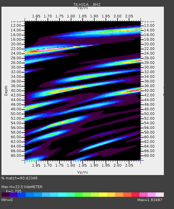
| Estimated Moho Depth: |
22.0 km |
| Estimated Crust Vp/Vs: |
1.71 |
| Assumed Crust Vp: |
6.53 km/s |
| Estimated Crust Vs: |
3.83 km/s |
| Estimated Crust Poisson's Ratio: |
0.24 |
|
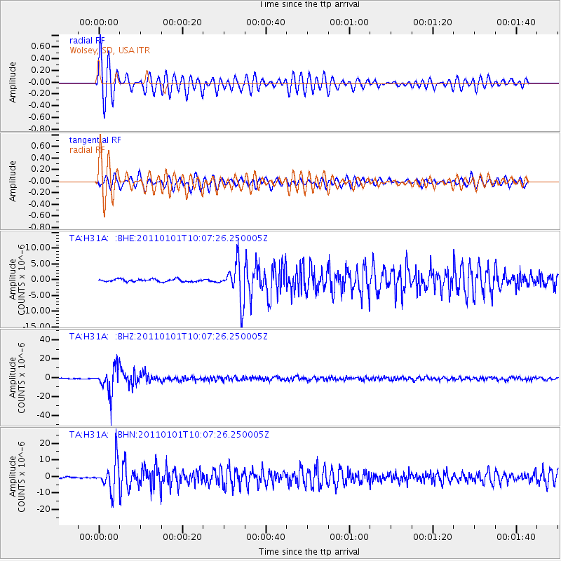
| Radial Match: |
90.62349 % |
| Radial Bump: |
365 |
| Transverse Match: |
75.045494 % |
| Transverse Bump: |
400 |
| SOD ConfigId: |
346946 |
| Insert Time: |
2011-07-04 08:08:03.241 +0000 |
| GWidth: |
2.5 |
| Max Bumps: |
400 |
| Tol: |
0.001 |
|
Signal To Noise
| Channel | StoN | STA | LTA |
| TA:H31A: :BHZ:20110101T10:07:26.250005Z | 41.285694 | 1.3866492E-5 | 3.3586676E-7 |
| TA:H31A: :BHN:20110101T10:07:26.250005Z | 27.643564 | 9.355413E-6 | 3.3843006E-7 |
| TA:H31A: :BHE:20110101T10:07:26.250005Z | 16.05252 | 6.1580445E-6 | 3.8361856E-7 |
| Arrivals |
| Ps | 2.4 SECOND |
| PpPs | 8.8 SECOND |
| PsPs/PpSs | 11 SECOND |


