You are here: Home > Network List > TA - USArray Transportable Network (new EarthScope stations) Stations List
> Station G32A Webster, SD, USA > Earthquake Result Viewer
G32A Webster, SD, USA - Earthquake Result Viewer
| Earthquake location: |
Santiago Del Estero Prov., Arg. |
| Earthquake latitude/longitude: |
-26.8/-63.1 |
| Earthquake time(UTC): |
2011/01/01 (001) 09:56:58 GMT |
| Earthquake Depth: |
577 km |
| Earthquake Magnitude: |
6.8 MB, 7.0 MW, 7.0 MW |
| Earthquake Catalog/Contributor: |
WHDF/NEIC |
|
| Network: |
TA USArray Transportable Network (new EarthScope stations) |
| Station: |
G32A Webster, SD, USA |
| Lat/Lon: |
45.26 N/97.50 W |
| Elevation: |
566 m |
|
| Distance: |
78.3 deg |
| Az: |
335.97 deg |
| Baz: |
148.984 deg |
| Ray Param: |
0.047977697 |
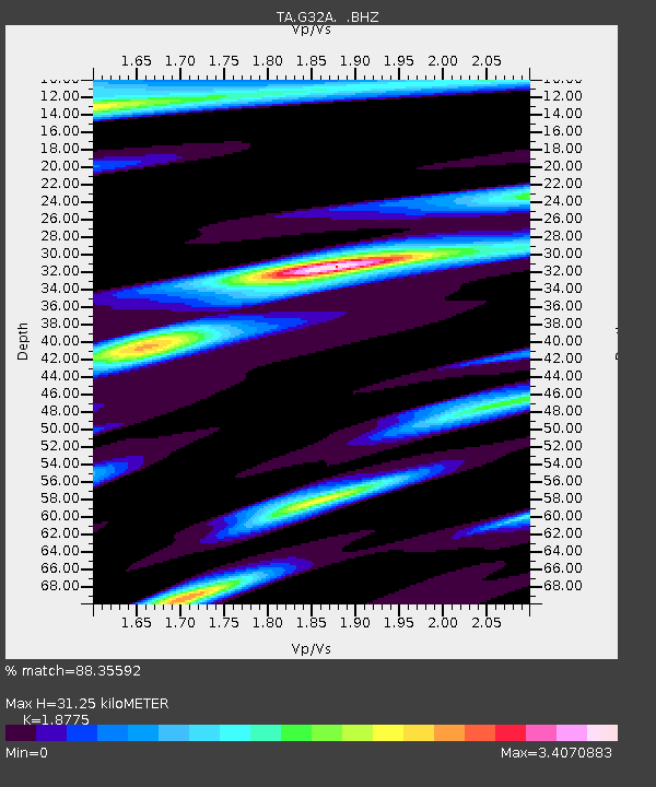
| Estimated Moho Depth: |
31.25 km |
| Estimated Crust Vp/Vs: |
1.88 |
| Assumed Crust Vp: |
6.552 km/s |
| Estimated Crust Vs: |
3.49 km/s |
| Estimated Crust Poisson's Ratio: |
0.30 |
|
| Radial Match: |
88.35592 % |
| Radial Bump: |
363 |
| Transverse Match: |
77.39079 % |
| Transverse Bump: |
271 |
| SOD ConfigId: |
346946 |
| Insert Time: |
2011-07-04 08:11:09.771 +0000 |
| GWidth: |
2.5 |
| Max Bumps: |
400 |
| Tol: |
0.001 |
|
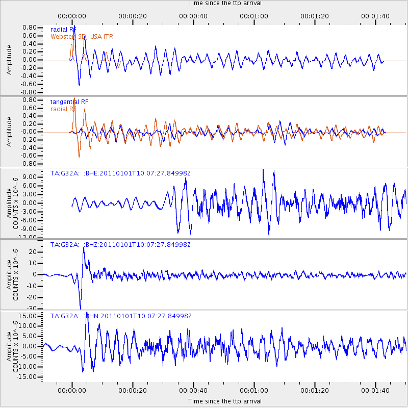
Signal To Noise
| Channel | StoN | STA | LTA |
| TA:G32A: :BHZ:20110101T10:07:27.84998Z | 32.24386 | 1.1939784E-5 | 3.7029633E-7 |
| TA:G32A: :BHN:20110101T10:07:27.84998Z | 5.7674627 | 6.05574E-6 | 1.0499834E-6 |
| TA:G32A: :BHE:20110101T10:07:27.84998Z | 3.0969837 | 3.3856743E-6 | 1.0932167E-6 |
| Arrivals |
| Ps | 4.3 SECOND |
| PpPs | 13 SECOND |
| PsPs/PpSs | 18 SECOND |


