You are here: Home > Network List > TA - USArray Transportable Network (new EarthScope stations) Stations List
> Station C38A Sawbill Landing (USFS), Superior Nat. Forest, MN, > Earthquake Result Viewer
C38A Sawbill Landing (USFS), Superior Nat. Forest, MN, - Earthquake Result Viewer
| Earthquake location: |
Santiago Del Estero Prov., Arg. |
| Earthquake latitude/longitude: |
-26.8/-63.1 |
| Earthquake time(UTC): |
2011/01/01 (001) 09:56:58 GMT |
| Earthquake Depth: |
577 km |
| Earthquake Magnitude: |
6.8 MB, 7.0 MW, 7.0 MW |
| Earthquake Catalog/Contributor: |
WHDF/NEIC |
|
| Network: |
TA USArray Transportable Network (new EarthScope stations) |
| Station: |
C38A Sawbill Landing (USFS), Superior Nat. Forest, MN, |
| Lat/Lon: |
47.72 N/91.27 W |
| Elevation: |
498 m |
|
| Distance: |
78.4 deg |
| Az: |
341.028 deg |
| Baz: |
154.513 deg |
| Ray Param: |
0.04789198 |
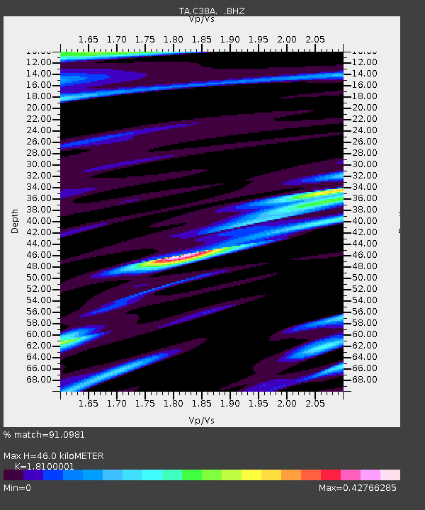
| Estimated Moho Depth: |
46.0 km |
| Estimated Crust Vp/Vs: |
1.81 |
| Assumed Crust Vp: |
6.467 km/s |
| Estimated Crust Vs: |
3.573 km/s |
| Estimated Crust Poisson's Ratio: |
0.28 |
|
| Radial Match: |
91.0981 % |
| Radial Bump: |
336 |
| Transverse Match: |
79.31466 % |
| Transverse Bump: |
400 |
| SOD ConfigId: |
346946 |
| Insert Time: |
2011-07-04 08:13:18.321 +0000 |
| GWidth: |
2.5 |
| Max Bumps: |
400 |
| Tol: |
0.001 |
|
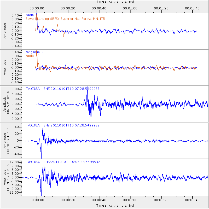
Signal To Noise
| Channel | StoN | STA | LTA |
| TA:C38A: :BHZ:20110101T10:07:28.549993Z | 27.209454 | 1.8014034E-5 | 6.620506E-7 |
| TA:C38A: :BHN:20110101T10:07:28.549993Z | 12.931243 | 5.317782E-6 | 4.1123516E-7 |
| TA:C38A: :BHE:20110101T10:07:28.549993Z | 7.461552 | 3.7073692E-6 | 4.96863E-7 |
| Arrivals |
| Ps | 5.9 SECOND |
| PpPs | 19 SECOND |
| PsPs/PpSs | 25 SECOND |


