You are here: Home > Network List > TA - USArray Transportable Network (new EarthScope stations) Stations List
> Station I37A Lemond, Waseca, MN, USA > Earthquake Result Viewer
I37A Lemond, Waseca, MN, USA - Earthquake Result Viewer

| Earthquake location: |
Santiago Del Estero Prov., Arg. |
| Earthquake latitude/longitude: |
-26.8/-63.1 |
| Earthquake time(UTC): |
2011/01/01 (001) 09:56:58 GMT |
| Earthquake Depth: |
577 km |
| Earthquake Magnitude: |
6.8 MB, 7.0 MW, 7.0 MW |
| Earthquake Catalog/Contributor: |
WHDF/NEIC |
|
| Network: |
TA USArray Transportable Network (new EarthScope stations) |
| Station: |
I37A Lemond, Waseca, MN, USA |
| Lat/Lon: |
44.01 N/93.40 W |
| Elevation: |
371 m |
|
| Distance: |
75.7 deg |
| Az: |
337.964 deg |
| Baz: |
152.304 deg |
| Ray Param: |
0.049614556 |
| Estimated Moho Depth: |
10.0 km |
| Estimated Crust Vp/Vs: |
1.60 |
| Assumed Crust Vp: |
6.571 km/s |
| Estimated Crust Vs: |
4.107 km/s |
| Estimated Crust Poisson's Ratio: |
0.18 |
|
| Radial Match: |
93.200905 % |
| Radial Bump: |
369 |
| Transverse Match: |
85.07787 % |
| Transverse Bump: |
400 |
| SOD ConfigId: |
346946 |
| Insert Time: |
2011-07-04 08:15:45.426 +0000 |
| GWidth: |
2.5 |
| Max Bumps: |
400 |
| Tol: |
0.001 |
|
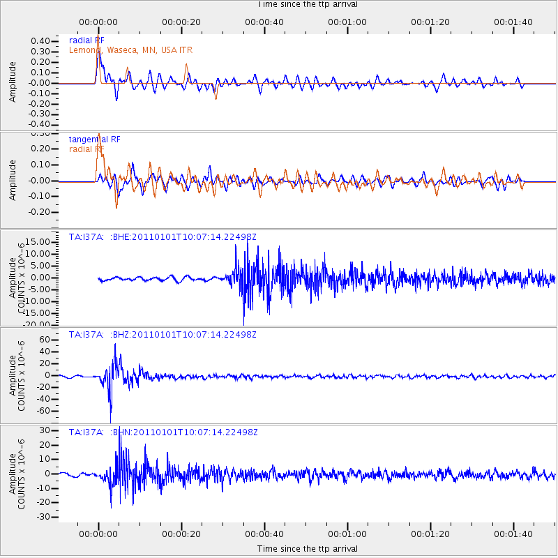
Signal To Noise
| Channel | StoN | STA | LTA |
| TA:I37A: :BHZ:20110101T10:07:14.22498Z | 21.548096 | 2.2542104E-5 | 1.0461298E-6 |
| TA:I37A: :BHN:20110101T10:07:14.22498Z | 6.220663 | 5.7430916E-6 | 9.2322813E-7 |
| TA:I37A: :BHE:20110101T10:07:14.22498Z | 4.761103 | 3.3734575E-6 | 7.085453E-7 |
| Arrivals |
| Ps | 0.9 SECOND |
| PpPs | 3.8 SECOND |
| PsPs/PpSs | 4.8 SECOND |


