You are here: Home > Network List > US - United States National Seismic Network Stations List
> Station MNTX Cornudas Mountains, Texas, USA > Earthquake Result Viewer
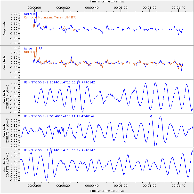
MNTX Cornudas Mountains, Texas, USA - Earthquake Result Viewer
*The percent match for this event was below the threshold and hence no stack was calculated.
| Earthquake location: |
Tonga Islands |
| Earthquake latitude/longitude: |
-16.4/-173.2 |
| Earthquake time(UTC): |
2014/01/14 (014) 14:59:38 GMT |
| Earthquake Depth: |
32 km |
| Earthquake Magnitude: |
5.3 MW |
| Earthquake Catalog/Contributor: |
ISC/ISC |
|
| Network: |
US United States National Seismic Network |
| Station: |
MNTX Cornudas Mountains, Texas, USA |
| Lat/Lon: |
31.70 N/105.38 W |
| Elevation: |
404 m |
|
| Distance: |
80.7 deg |
| Az: |
53.134 deg |
| Baz: |
244.292 deg |
| Ray Param: |
$rayparam |
*The percent match for this event was below the threshold and hence was not used in the summary stack. |
|
| Radial Match: |
76.496994 % |
| Radial Bump: |
376 |
| Transverse Match: |
35.549103 % |
| Transverse Bump: |
287 |
| SOD ConfigId: |
3390531 |
| Insert Time: |
2019-04-10 00:02:14.557 +0000 |
| GWidth: |
2.5 |
| Max Bumps: |
400 |
| Tol: |
0.001 |
|
Signal To Noise
| Channel | StoN | STA | LTA |
| US:MNTX:00:BHZ:20140114T15:11:17.474014Z | 0.397589 | 9.3571295E-8 | 2.3534679E-7 |
| US:MNTX:00:BH1:20140114T15:11:17.474014Z | 2.4674878 | 4.06661E-7 | 1.648077E-7 |
| US:MNTX:00:BH2:20140114T15:11:17.474014Z | 1.9505712 | 5.7050715E-7 | 2.924821E-7 |
| Arrivals |
| Ps | |
| PpPs | |
| PsPs/PpSs | |


