You are here: Home > Network List > TA - USArray Transportable Network (new EarthScope stations) Stations List
> Station F32A Veblen, SD, USA > Earthquake Result Viewer
F32A Veblen, SD, USA - Earthquake Result Viewer
| Earthquake location: |
Santiago Del Estero Prov., Arg. |
| Earthquake latitude/longitude: |
-26.8/-63.1 |
| Earthquake time(UTC): |
2011/01/01 (001) 09:56:58 GMT |
| Earthquake Depth: |
577 km |
| Earthquake Magnitude: |
6.8 MB, 7.0 MW, 7.0 MW |
| Earthquake Catalog/Contributor: |
WHDF/NEIC |
|
| Network: |
TA USArray Transportable Network (new EarthScope stations) |
| Station: |
F32A Veblen, SD, USA |
| Lat/Lon: |
45.87 N/97.13 W |
| Elevation: |
371 m |
|
| Distance: |
78.6 deg |
| Az: |
336.522 deg |
| Baz: |
149.36 deg |
| Ray Param: |
0.04771537 |
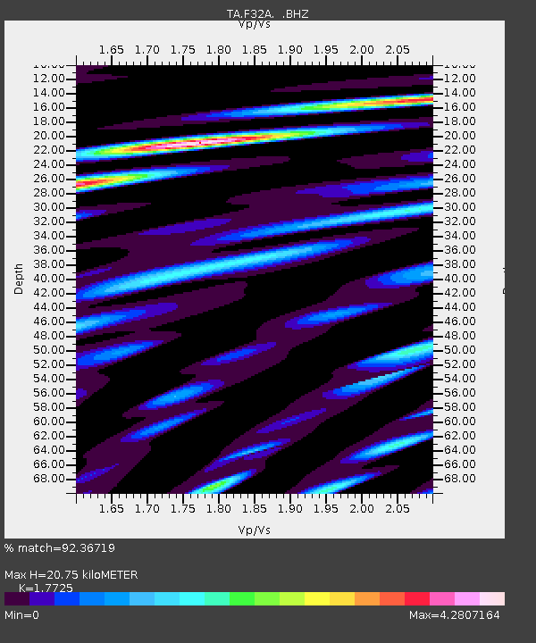
| Estimated Moho Depth: |
20.75 km |
| Estimated Crust Vp/Vs: |
1.77 |
| Assumed Crust Vp: |
6.552 km/s |
| Estimated Crust Vs: |
3.697 km/s |
| Estimated Crust Poisson's Ratio: |
0.27 |
|
| Radial Match: |
92.36719 % |
| Radial Bump: |
400 |
| Transverse Match: |
84.2009 % |
| Transverse Bump: |
400 |
| SOD ConfigId: |
346946 |
| Insert Time: |
2011-07-04 08:18:01.904 +0000 |
| GWidth: |
2.5 |
| Max Bumps: |
400 |
| Tol: |
0.001 |
|
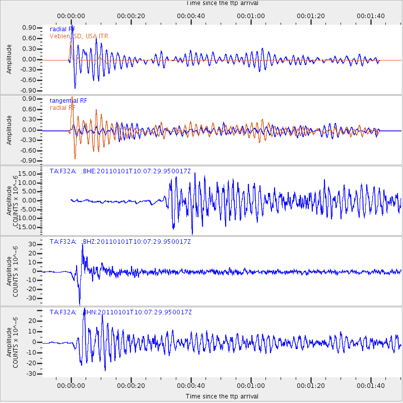
Signal To Noise
| Channel | StoN | STA | LTA |
| TA:F32A: :BHZ:20110101T10:07:29.950017Z | 50.13069 | 1.2786422E-5 | 2.5506176E-7 |
| TA:F32A: :BHN:20110101T10:07:29.950017Z | 28.574226 | 1.2259638E-5 | 4.2904534E-7 |
| TA:F32A: :BHE:20110101T10:07:29.950017Z | 15.273583 | 6.548246E-6 | 4.2873017E-7 |
| Arrivals |
| Ps | 2.5 SECOND |
| PpPs | 8.5 SECOND |
| PsPs/PpSs | 11 SECOND |


