You are here: Home > Network List > TA - USArray Transportable Network (new EarthScope stations) Stations List
> Station N54A Moraine State Park, Portersville, PA, USA > Earthquake Result Viewer
N54A Moraine State Park, Portersville, PA, USA - Earthquake Result Viewer
| Earthquake location: |
Santiago Del Estero Prov., Arg. |
| Earthquake latitude/longitude: |
-26.8/-63.1 |
| Earthquake time(UTC): |
2011/01/01 (001) 09:56:58 GMT |
| Earthquake Depth: |
577 km |
| Earthquake Magnitude: |
6.8 MB, 7.0 MW, 7.0 MW |
| Earthquake Catalog/Contributor: |
WHDF/NEIC |
|
| Network: |
TA USArray Transportable Network (new EarthScope stations) |
| Station: |
N54A Moraine State Park, Portersville, PA, USA |
| Lat/Lon: |
40.96 N/79.99 W |
| Elevation: |
408 m |
|
| Distance: |
69.2 deg |
| Az: |
346.417 deg |
| Baz: |
163.909 deg |
| Ray Param: |
0.053778667 |
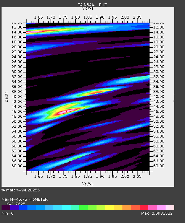
| Estimated Moho Depth: |
45.75 km |
| Estimated Crust Vp/Vs: |
1.76 |
| Assumed Crust Vp: |
6.121 km/s |
| Estimated Crust Vs: |
3.473 km/s |
| Estimated Crust Poisson's Ratio: |
0.26 |
|
| Radial Match: |
94.20255 % |
| Radial Bump: |
400 |
| Transverse Match: |
88.07139 % |
| Transverse Bump: |
370 |
| SOD ConfigId: |
346946 |
| Insert Time: |
2011-07-04 08:19:30.005 +0000 |
| GWidth: |
2.5 |
| Max Bumps: |
400 |
| Tol: |
0.001 |
|
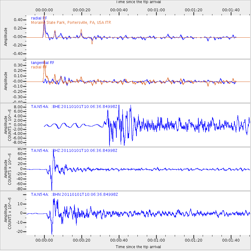
Signal To Noise
| Channel | StoN | STA | LTA |
| TA:N54A: :BHZ:20110101T10:06:36.84998Z | 54.39707 | 2.5087595E-5 | 4.6119382E-7 |
| TA:N54A: :BHN:20110101T10:06:36.84998Z | 14.058121 | 6.7021497E-6 | 4.7674578E-7 |
| TA:N54A: :BHE:20110101T10:06:36.84998Z | 3.4621005 | 2.0967018E-6 | 6.0561547E-7 |
| Arrivals |
| Ps | 5.9 SECOND |
| PpPs | 20 SECOND |
| PsPs/PpSs | 26 SECOND |


