You are here: Home > Network List > TA - USArray Transportable Network (new EarthScope stations) Stations List
> Station Q38A Cook's Store, Concordia, MO, USA > Earthquake Result Viewer
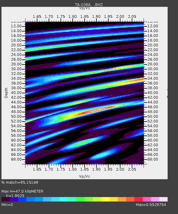
Q38A Cook's Store, Concordia, MO, USA - Earthquake Result Viewer
| Earthquake location: |
Santiago Del Estero Prov., Arg. |
| Earthquake latitude/longitude: |
-26.8/-63.1 |
| Earthquake time(UTC): |
2011/01/01 (001) 09:56:58 GMT |
| Earthquake Depth: |
577 km |
| Earthquake Magnitude: |
6.8 MB, 7.0 MW, 7.0 MW |
| Earthquake Catalog/Contributor: |
WHDF/NEIC |
|
| Network: |
TA USArray Transportable Network (new EarthScope stations) |
| Station: |
Q38A Cook's Store, Concordia, MO, USA |
| Lat/Lon: |
38.96 N/93.62 W |
| Elevation: |
228 m |
|
| Distance: |
71.4 deg |
| Az: |
335.331 deg |
| Baz: |
151.413 deg |
| Ray Param: |
0.052422866 |
| Estimated Moho Depth: |
47.0 km |
| Estimated Crust Vp/Vs: |
1.90 |
| Assumed Crust Vp: |
6.498 km/s |
| Estimated Crust Vs: |
3.415 km/s |
| Estimated Crust Poisson's Ratio: |
0.31 |
|
| Radial Match: |
95.15169 % |
| Radial Bump: |
325 |
| Transverse Match: |
83.7889 % |
| Transverse Bump: |
400 |
| SOD ConfigId: |
346946 |
| Insert Time: |
2011-07-04 08:23:11.946 +0000 |
| GWidth: |
2.5 |
| Max Bumps: |
400 |
| Tol: |
0.001 |
|

Signal To Noise
| Channel | StoN | STA | LTA |
| TA:Q38A: :BHZ:20110101T10:06:49.47498Z | 69.11644 | 1.8731409E-5 | 2.7101237E-7 |
| TA:Q38A: :BHN:20110101T10:06:49.47498Z | 30.91379 | 6.3014822E-6 | 2.038405E-7 |
| TA:Q38A: :BHE:20110101T10:06:49.47498Z | 12.950603 | 3.4654392E-6 | 2.6758903E-7 |
| Arrivals |
| Ps | 6.7 SECOND |
| PpPs | 20 SECOND |
| PsPs/PpSs | 27 SECOND |


