You are here: Home > Network List > US - United States National Seismic Network Stations List
> Station ERPA Erie, Pennsylvania, USA > Earthquake Result Viewer
ERPA Erie, Pennsylvania, USA - Earthquake Result Viewer
| Earthquake location: |
Santiago Del Estero Prov., Arg. |
| Earthquake latitude/longitude: |
-26.8/-63.1 |
| Earthquake time(UTC): |
2011/01/01 (001) 09:56:58 GMT |
| Earthquake Depth: |
577 km |
| Earthquake Magnitude: |
6.8 MB, 7.0 MW, 7.0 MW |
| Earthquake Catalog/Contributor: |
WHDF/NEIC |
|
| Network: |
US United States National Seismic Network |
| Station: |
ERPA Erie, Pennsylvania, USA |
| Lat/Lon: |
42.12 N/79.99 W |
| Elevation: |
306 m |
|
| Distance: |
70.3 deg |
| Az: |
346.757 deg |
| Baz: |
164.026 deg |
| Ray Param: |
0.05308424 |
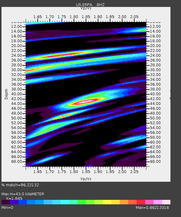
| Estimated Moho Depth: |
43.0 km |
| Estimated Crust Vp/Vs: |
1.85 |
| Assumed Crust Vp: |
6.419 km/s |
| Estimated Crust Vs: |
3.479 km/s |
| Estimated Crust Poisson's Ratio: |
0.29 |
|
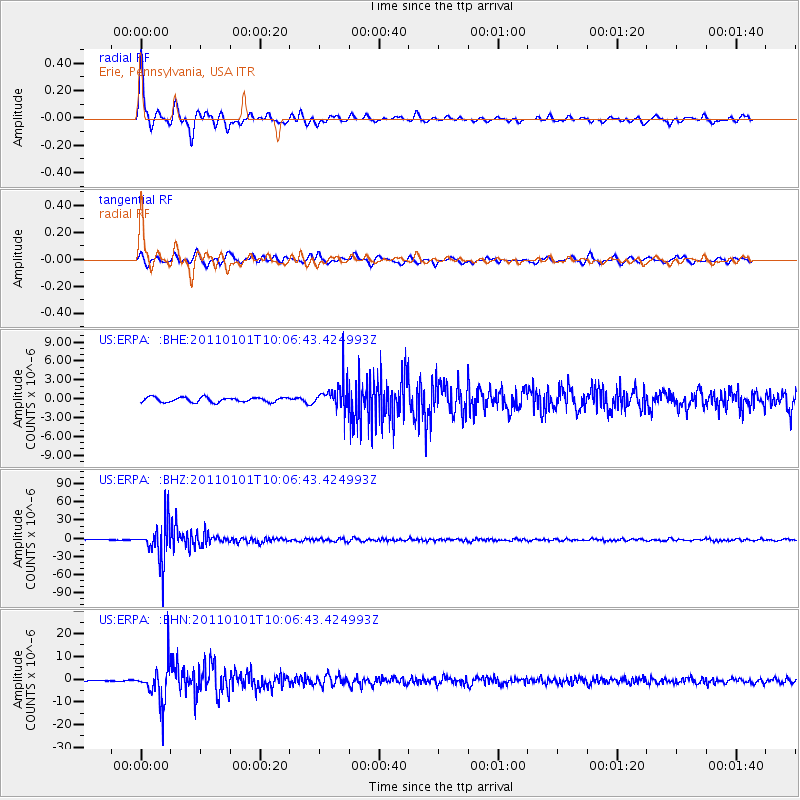
| Radial Match: |
96.22132 % |
| Radial Bump: |
358 |
| Transverse Match: |
88.74835 % |
| Transverse Bump: |
383 |
| SOD ConfigId: |
346946 |
| Insert Time: |
2011-07-04 08:31:23.207 +0000 |
| GWidth: |
2.5 |
| Max Bumps: |
400 |
| Tol: |
0.001 |
|
Signal To Noise
| Channel | StoN | STA | LTA |
| US:ERPA: :BHZ:20110101T10:06:43.424993Z | 119.02479 | 3.2706954E-5 | 2.747911E-7 |
| US:ERPA: :BHN:20110101T10:06:43.424993Z | 22.225657 | 8.389456E-6 | 3.774672E-7 |
| US:ERPA: :BHE:20110101T10:06:43.424993Z | 5.919718 | 2.2605107E-6 | 3.818612E-7 |
| Arrivals |
| Ps | 5.8 SECOND |
| PpPs | 18 SECOND |
| PsPs/PpSs | 24 SECOND |


