You are here: Home > Network List > US - United States National Seismic Network Stations List
> Station DGMT Dagmar, Montana, USA > Earthquake Result Viewer
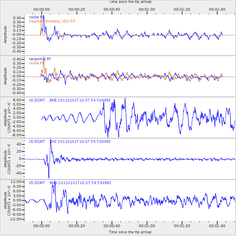
DGMT Dagmar, Montana, USA - Earthquake Result Viewer
*The percent match for this event was below the threshold and hence no stack was calculated.
| Earthquake location: |
Santiago Del Estero Prov., Arg. |
| Earthquake latitude/longitude: |
-26.8/-63.1 |
| Earthquake time(UTC): |
2011/01/01 (001) 09:56:58 GMT |
| Earthquake Depth: |
577 km |
| Earthquake Magnitude: |
6.8 MB, 7.0 MW, 7.0 MW |
| Earthquake Catalog/Contributor: |
WHDF/NEIC |
|
| Network: |
US United States National Seismic Network |
| Station: |
DGMT Dagmar, Montana, USA |
| Lat/Lon: |
48.47 N/104.20 W |
| Elevation: |
0.0 m |
|
| Distance: |
83.5 deg |
| Az: |
333.897 deg |
| Baz: |
143.779 deg |
| Ray Param: |
$rayparam |
*The percent match for this event was below the threshold and hence was not used in the summary stack. |
|
| Radial Match: |
85.950554 % |
| Radial Bump: |
267 |
| Transverse Match: |
90.525276 % |
| Transverse Bump: |
393 |
| SOD ConfigId: |
346946 |
| Insert Time: |
2011-07-04 08:31:43.228 +0000 |
| GWidth: |
2.5 |
| Max Bumps: |
400 |
| Tol: |
0.001 |
|
Signal To Noise
| Channel | StoN | STA | LTA |
| US:DGMT: :BHZ:20110101T10:07:54.59998Z | 42.975876 | 1.4887092E-5 | 3.4640576E-7 |
| US:DGMT: :BHN:20110101T10:07:54.59998Z | 3.6196313 | 2.6880302E-6 | 7.4262545E-7 |
| US:DGMT: :BHE:20110101T10:07:54.59998Z | 1.5373622 | 1.7593786E-6 | 1.1444139E-6 |
| Arrivals |
| Ps | |
| PpPs | |
| PsPs/PpSs | |


