You are here: Home > Network List > US - United States National Seismic Network Stations List
> Station AMTX Amarillo, Texas, USA > Earthquake Result Viewer
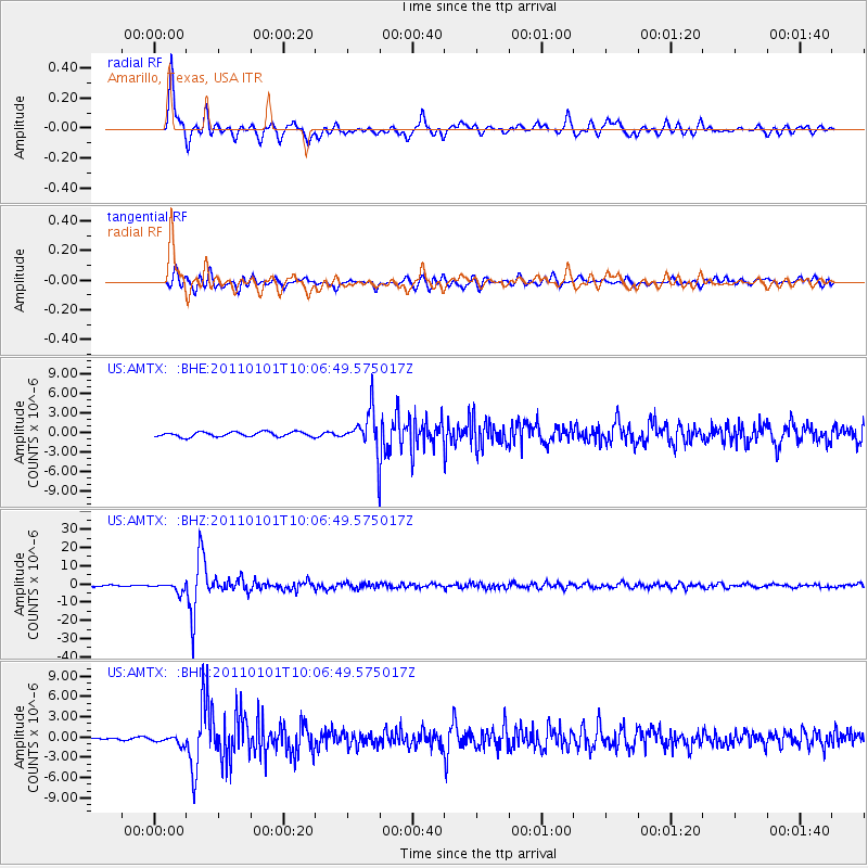
AMTX Amarillo, Texas, USA - Earthquake Result Viewer
*The percent match for this event was below the threshold and hence no stack was calculated.
| Earthquake location: |
Santiago Del Estero Prov., Arg. |
| Earthquake latitude/longitude: |
-26.8/-63.1 |
| Earthquake time(UTC): |
2011/01/01 (001) 09:56:58 GMT |
| Earthquake Depth: |
577 km |
| Earthquake Magnitude: |
6.8 MB, 7.0 MW, 7.0 MW |
| Earthquake Catalog/Contributor: |
WHDF/NEIC |
|
| Network: |
US United States National Seismic Network |
| Station: |
AMTX Amarillo, Texas, USA |
| Lat/Lon: |
34.53 N/101.41 W |
| Elevation: |
1010 m |
|
| Distance: |
71.0 deg |
| Az: |
327.25 deg |
| Baz: |
144.151 deg |
| Ray Param: |
$rayparam |
*The percent match for this event was below the threshold and hence was not used in the summary stack. |
|
| Radial Match: |
92.31909 % |
| Radial Bump: |
400 |
| Transverse Match: |
84.4681 % |
| Transverse Bump: |
400 |
| SOD ConfigId: |
346946 |
| Insert Time: |
2011-07-04 08:32:23.396 +0000 |
| GWidth: |
2.5 |
| Max Bumps: |
400 |
| Tol: |
0.001 |
|
Signal To Noise
| Channel | StoN | STA | LTA |
| US:AMTX: :BHZ:20110101T10:06:49.575017Z | 4.933126 | 2.367348E-6 | 4.7988806E-7 |
| US:AMTX: :BHN:20110101T10:06:49.575017Z | 3.4126315 | 7.311824E-7 | 2.1425765E-7 |
| US:AMTX: :BHE:20110101T10:06:49.575017Z | 1.5987664 | 5.8160737E-7 | 3.6378506E-7 |
| Arrivals |
| Ps | |
| PpPs | |
| PsPs/PpSs | |


