You are here: Home > Network List > US - United States National Seismic Network Stations List
> Station LONY Lake Ozonia, New York, USA > Earthquake Result Viewer
LONY Lake Ozonia, New York, USA - Earthquake Result Viewer
| Earthquake location: |
Santiago Del Estero Prov., Arg. |
| Earthquake latitude/longitude: |
-26.8/-63.1 |
| Earthquake time(UTC): |
2011/01/01 (001) 09:56:58 GMT |
| Earthquake Depth: |
577 km |
| Earthquake Magnitude: |
6.8 MB, 7.0 MW, 7.0 MW |
| Earthquake Catalog/Contributor: |
WHDF/NEIC |
|
| Network: |
US United States National Seismic Network |
| Station: |
LONY Lake Ozonia, New York, USA |
| Lat/Lon: |
44.62 N/74.58 W |
| Elevation: |
440 m |
|
| Distance: |
71.8 deg |
| Az: |
351.422 deg |
| Baz: |
169.241 deg |
| Ray Param: |
0.052113134 |
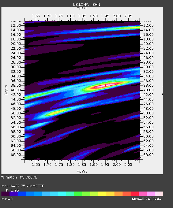
| Estimated Moho Depth: |
37.75 km |
| Estimated Crust Vp/Vs: |
1.95 |
| Assumed Crust Vp: |
6.419 km/s |
| Estimated Crust Vs: |
3.292 km/s |
| Estimated Crust Poisson's Ratio: |
0.32 |
|
| Radial Match: |
95.70676 % |
| Radial Bump: |
247 |
| Transverse Match: |
93.57459 % |
| Transverse Bump: |
379 |
| SOD ConfigId: |
346946 |
| Insert Time: |
2011-07-04 08:33:11.355 +0000 |
| GWidth: |
2.5 |
| Max Bumps: |
400 |
| Tol: |
0.001 |
|

Signal To Noise
| Channel | StoN | STA | LTA |
| US:LONY: :BHZ:20110101T10:06:52.275029Z | 62.905533 | 1.6009011E-5 | 2.544929E-7 |
| US:LONY: :BHN:20110101T10:06:52.275029Z | 16.852552 | 5.3207614E-6 | 3.1572438E-7 |
| US:LONY: :BHE:20110101T10:06:52.275029Z | 8.428711 | 2.8236645E-6 | 3.3500552E-7 |
| Arrivals |
| Ps | 5.8 SECOND |
| PpPs | 17 SECOND |
| PsPs/PpSs | 23 SECOND |


