You are here: Home > Network List > UW - Pacific Northwest Regional Seismic Network Stations List
> Station IRON Circle Bar Ranch, Crane, OR, USA > Earthquake Result Viewer
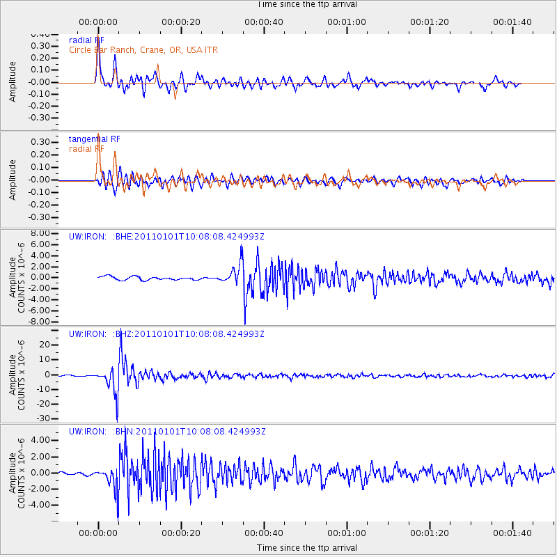
IRON Circle Bar Ranch, Crane, OR, USA - Earthquake Result Viewer
| Earthquake location: |
Santiago Del Estero Prov., Arg. |
| Earthquake latitude/longitude: |
-26.8/-63.1 |
| Earthquake time(UTC): |
2011/01/01 (001) 09:56:58 GMT |
| Earthquake Depth: |
577 km |
| Earthquake Magnitude: |
6.8 MB, 7.0 MW, 7.0 MW |
| Earthquake Catalog/Contributor: |
WHDF/NEIC |
|
| Network: |
UW Pacific Northwest Regional Seismic Network |
| Station: |
IRON Circle Bar Ranch, Crane, OR, USA |
| Lat/Lon: |
43.36 N/118.47 W |
| Elevation: |
1229 m |
|
| Distance: |
86.3 deg |
| Az: |
323.047 deg |
| Baz: |
132.552 deg |
| Ray Param: |
0.042466547 |
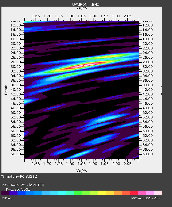
| Estimated Moho Depth: |
29.25 km |
| Estimated Crust Vp/Vs: |
1.86 |
| Assumed Crust Vp: |
6.279 km/s |
| Estimated Crust Vs: |
3.38 km/s |
| Estimated Crust Poisson's Ratio: |
0.30 |
|
| Radial Match: |
90.33212 % |
| Radial Bump: |
400 |
| Transverse Match: |
85.74975 % |
| Transverse Bump: |
400 |
| SOD ConfigId: |
346946 |
| Insert Time: |
2011-07-04 08:37:58.113 +0000 |
| GWidth: |
2.5 |
| Max Bumps: |
400 |
| Tol: |
0.001 |
|
Signal To Noise
| Channel | StoN | STA | LTA |
| UW:IRON: :BHZ:20110101T10:08:08.424993Z | 29.082449 | 8.942402E-6 | 3.074845E-7 |
| UW:IRON: :BHN:20110101T10:08:08.424993Z | 11.1596 | 1.4882534E-6 | 1.3336081E-7 |
| UW:IRON: :BHE:20110101T10:08:08.424993Z | 5.9173145 | 1.8713978E-6 | 3.1625794E-7 |
| Arrivals |
| Ps | 4.1 SECOND |
| PpPs | 13 SECOND |
| PsPs/PpSs | 17 SECOND |


