You are here: Home > Network List > TA - USArray Transportable Network (new EarthScope stations) Stations List
> Station G59A Clarenceville, QC, USA > Earthquake Result Viewer
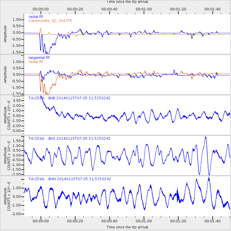
G59A Clarenceville, QC, USA - Earthquake Result Viewer
*The percent match for this event was below the threshold and hence no stack was calculated.
| Earthquake location: |
Sea Of Okhotsk |
| Earthquake latitude/longitude: |
51.5/151.0 |
| Earthquake time(UTC): |
2014/01/15 (015) 06:55:09 GMT |
| Earthquake Depth: |
551 km |
| Earthquake Magnitude: |
4.6 mb |
| Earthquake Catalog/Contributor: |
ISC/ISC |
|
| Network: |
TA USArray Transportable Network (new EarthScope stations) |
| Station: |
G59A Clarenceville, QC, USA |
| Lat/Lon: |
45.08 N/73.18 W |
| Elevation: |
36 m |
|
| Distance: |
76.5 deg |
| Az: |
30.496 deg |
| Baz: |
333.413 deg |
| Ray Param: |
$rayparam |
*The percent match for this event was below the threshold and hence was not used in the summary stack. |
|
| Radial Match: |
34.45574 % |
| Radial Bump: |
400 |
| Transverse Match: |
51.369465 % |
| Transverse Bump: |
400 |
| SOD ConfigId: |
3390531 |
| Insert Time: |
2019-04-10 00:08:08.359 +0000 |
| GWidth: |
2.5 |
| Max Bumps: |
400 |
| Tol: |
0.001 |
|
Signal To Noise
| Channel | StoN | STA | LTA |
| TA:G59A: :BHZ:20140115T07:05:31.525024Z | 1.0192375 | 4.2344578E-7 | 4.154535E-7 |
| TA:G59A: :BHN:20140115T07:05:31.525024Z | 0.94715285 | 1.0025597E-6 | 1.0584984E-6 |
| TA:G59A: :BHE:20140115T07:05:31.525024Z | 0.97507614 | 1.0270724E-6 | 1.0533254E-6 |
| Arrivals |
| Ps | |
| PpPs | |
| PsPs/PpSs | |


