You are here: Home > Network List > AZ - ANZA Regional Network Stations List
> Station FRD AZ.FRD > Earthquake Result Viewer
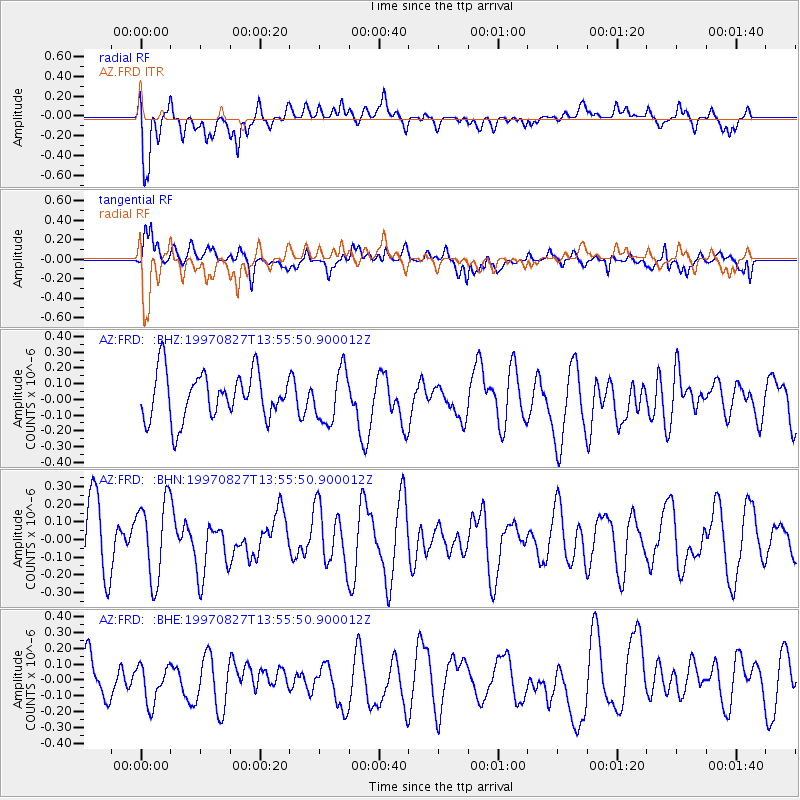
FRD AZ.FRD - Earthquake Result Viewer
*The percent match for this event was below the threshold and hence no stack was calculated.
| Earthquake location: |
New Britain Region, P.N.G. |
| Earthquake latitude/longitude: |
-6.0/148.6 |
| Earthquake time(UTC): |
1997/08/27 (239) 13:42:52 GMT |
| Earthquake Depth: |
33 km |
| Earthquake Magnitude: |
5.7 MB, 5.7 MS, 6.0 UNKNOWN, 5.9 MW |
| Earthquake Catalog/Contributor: |
WHDF/NEIC |
|
| Network: |
AZ ANZA Regional Network |
| Station: |
FRD AZ.FRD |
| Lat/Lon: |
33.49 N/116.60 W |
| Elevation: |
1164 m |
|
| Distance: |
97.3 deg |
| Az: |
57.086 deg |
| Baz: |
267.632 deg |
| Ray Param: |
$rayparam |
*The percent match for this event was below the threshold and hence was not used in the summary stack. |
|
| Radial Match: |
75.35035 % |
| Radial Bump: |
400 |
| Transverse Match: |
60.022705 % |
| Transverse Bump: |
400 |
| SOD ConfigId: |
4480 |
| Insert Time: |
2010-02-26 19:18:42.301 +0000 |
| GWidth: |
2.5 |
| Max Bumps: |
400 |
| Tol: |
0.001 |
|
Signal To Noise
| Channel | StoN | STA | LTA |
| AZ:FRD: :BHN:19970827T13:55:50.900012Z | 1.4388174 | 2.23685E-7 | 1.5546449E-7 |
| AZ:FRD: :BHE:19970827T13:55:50.900012Z | 1.0837281 | 1.216855E-7 | 1.12284155E-7 |
| AZ:FRD: :BHZ:19970827T13:55:50.900012Z | 1.1060038 | 1.6427423E-7 | 1.4852954E-7 |
| Arrivals |
| Ps | |
| PpPs | |
| PsPs/PpSs | |


