You are here: Home > Network List > KN - Kyrgyz Seismic Telemetry Network Stations List
> Station TKM2 KN.TKM2 > Earthquake Result Viewer
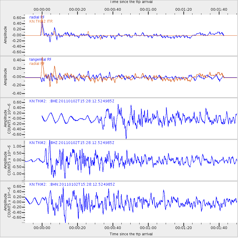
TKM2 KN.TKM2 - Earthquake Result Viewer
*The percent match for this event was below the threshold and hence no stack was calculated.
| Earthquake location: |
Southern Sumatra, Indonesia |
| Earthquake latitude/longitude: |
-4.5/101.4 |
| Earthquake time(UTC): |
2011/01/02 (002) 15:19:31 GMT |
| Earthquake Depth: |
22 km |
| Earthquake Magnitude: |
5.7 MB, 5.6 MS, 5.8 MW, 5.7 MW |
| Earthquake Catalog/Contributor: |
WHDF/NEIC |
|
| Network: |
KN Kyrgyz Seismic Telemetry Network |
| Station: |
TKM2 KN.TKM2 |
| Lat/Lon: |
42.92 N/75.60 E |
| Elevation: |
2020 m |
|
| Distance: |
52.6 deg |
| Az: |
336.254 deg |
| Baz: |
146.869 deg |
| Ray Param: |
$rayparam |
*The percent match for this event was below the threshold and hence was not used in the summary stack. |
|
| Radial Match: |
78.831436 % |
| Radial Bump: |
400 |
| Transverse Match: |
68.69263 % |
| Transverse Bump: |
400 |
| SOD ConfigId: |
346946 |
| Insert Time: |
2011-07-04 08:47:31.189 +0000 |
| GWidth: |
2.5 |
| Max Bumps: |
400 |
| Tol: |
0.001 |
|
Signal To Noise
| Channel | StoN | STA | LTA |
| KN:TKM2: :BHZ:20110102T15:28:12.524985Z | 6.92101 | 5.5394247E-7 | 8.003781E-8 |
| KN:TKM2: :BHN:20110102T15:28:12.524985Z | 2.7974265 | 2.0672827E-7 | 7.389945E-8 |
| KN:TKM2: :BHE:20110102T15:28:12.524985Z | 1.5361544 | 1.4954182E-7 | 9.734816E-8 |
| Arrivals |
| Ps | |
| PpPs | |
| PsPs/PpSs | |


