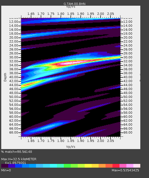
TAM Tamanrasset, Algeria - Earthquake Result Viewer
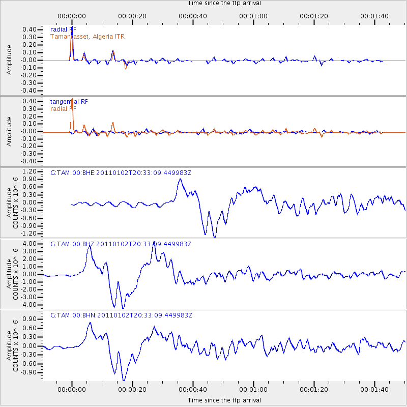
Earthquake location: Near Coast Of Central Chile
Earthquake latitude/longitude: -38.4/-73.3
Earthquake time(UTC): 2011/01/02 (002) 20:20:17 GMT
Earthquake Depth: 24 km
Earthquake Magnitude: 6.6 MB, 7.1 MS, 7.1 MW, 7.0 MW
Earthquake Catalog/Contributor: WHDF/NEIC
Network: G GEOSCOPE
Station: TAM Tamanrasset, Algeria
Lat/Lon: 22.79 N/5.53 E
Elevation: 1377 m
Distance: 95.6 deg
Az: 65.477 deg
Baz: 230.813 deg
Ray Param: 0.040728275
Estimated Moho Depth: 32.5 km
Estimated Crust Vp/Vs: 1.86
Assumed Crust Vp: 6.61 km/s
Estimated Crust Vs: 3.559 km/s
Estimated Crust Poisson's Ratio: 0.30
Radial Match: 98.56148 %
Radial Bump: 293
Transverse Match: 80.26084 %
Transverse Bump: 400
SOD ConfigId: 346946
Insert Time: 2011-07-04 08:56:07.215 +0000
GWidth: 2.5
Max Bumps: 400
Tol: 0.001

Signal To Noise

ChannelStoNSTALTA
G:TAM:00:BHZ:20110102T20:33:09.449983Z9.2841296.6693985E-77.183656E-8
G:TAM:00:BHN:20110102T20:33:09.449983Z3.7399021.4623336E-73.910085E-8
G:TAM:00:BHE:20110102T20:33:09.449983Z2.7766391.6323605E-75.878908E-8
Arrivals
Ps4.3 SECOND
PpPs14 SECOND
PsPs/PpSs18 SECOND