You are here: Home > Network List > UW - Pacific Northwest Regional Seismic Network Stations List
> Station LEBA Lebam, WA, USA > Earthquake Result Viewer
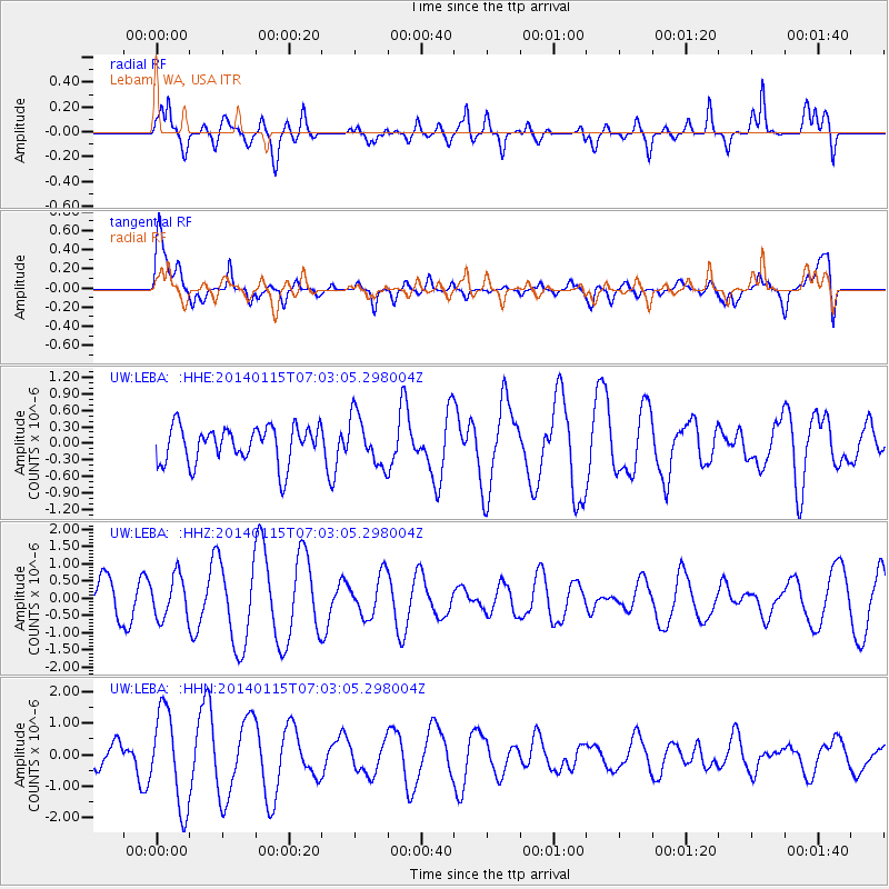
LEBA Lebam, WA, USA - Earthquake Result Viewer
*The percent match for this event was below the threshold and hence no stack was calculated.
| Earthquake location: |
Sea Of Okhotsk |
| Earthquake latitude/longitude: |
51.5/151.0 |
| Earthquake time(UTC): |
2014/01/15 (015) 06:55:09 GMT |
| Earthquake Depth: |
551 km |
| Earthquake Magnitude: |
4.6 mb |
| Earthquake Catalog/Contributor: |
ISC/ISC |
|
| Network: |
UW Pacific Northwest Regional Seismic Network |
| Station: |
LEBA Lebam, WA, USA |
| Lat/Lon: |
46.55 N/123.56 W |
| Elevation: |
73 m |
|
| Distance: |
53.2 deg |
| Az: |
59.236 deg |
| Baz: |
308.932 deg |
| Ray Param: |
$rayparam |
*The percent match for this event was below the threshold and hence was not used in the summary stack. |
|
| Radial Match: |
47.00842 % |
| Radial Bump: |
400 |
| Transverse Match: |
56.01213 % |
| Transverse Bump: |
400 |
| SOD ConfigId: |
3390531 |
| Insert Time: |
2019-04-10 00:09:45.845 +0000 |
| GWidth: |
2.5 |
| Max Bumps: |
400 |
| Tol: |
0.001 |
|
Signal To Noise
| Channel | StoN | STA | LTA |
| UW:LEBA: :HHZ:20140115T07:03:05.298004Z | 0.9017859 | 6.050681E-7 | 6.7096653E-7 |
| UW:LEBA: :HHN:20140115T07:03:05.298004Z | 3.3914464 | 1.5042275E-6 | 4.435357E-7 |
| UW:LEBA: :HHE:20140115T07:03:05.298004Z | 1.3546075 | 4.5300484E-7 | 3.344178E-7 |
| Arrivals |
| Ps | |
| PpPs | |
| PsPs/PpSs | |


