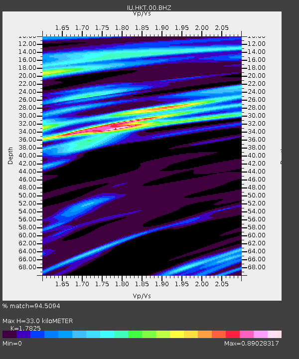
HKT Hockley, Texas - Earthquake Result Viewer
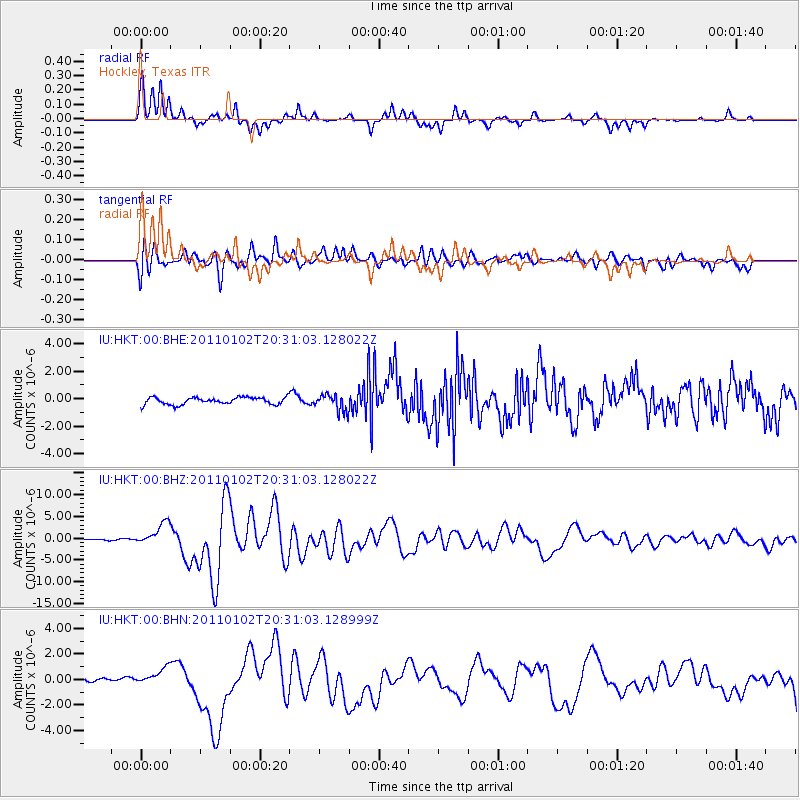
Earthquake location: Near Coast Of Central Chile
Earthquake latitude/longitude: -38.4/-73.3
Earthquake time(UTC): 2011/01/02 (002) 20:20:17 GMT
Earthquake Depth: 24 km
Earthquake Magnitude: 6.6 MB, 7.1 MS, 7.1 MW, 7.0 MW
Earthquake Catalog/Contributor: WHDF/NEIC
Network: IU Global Seismograph Network (GSN - IRIS/USGS)
Station: HKT Hockley, Texas
Lat/Lon: 29.96 N/95.84 W
Elevation: -413.0 m
Distance: 71.1 deg
Az: 339.445 deg
Baz: 161.452 deg
Ray Param: 0.05448946
Estimated Moho Depth: 33.0 km
Estimated Crust Vp/Vs: 1.78
Assumed Crust Vp: 5.581 km/s
Estimated Crust Vs: 3.131 km/s
Estimated Crust Poisson's Ratio: 0.27
Radial Match: 94.5094 %
Radial Bump: 277
Transverse Match: 82.9832 %
Transverse Bump: 400
SOD ConfigId: 346946
Insert Time: 2011-07-04 08:58:42.363 +0000
GWidth: 2.5
Max Bumps: 400
Tol: 0.001

Signal To Noise

ChannelStoNSTALTA
IU:HKT:00:BHZ:20110102T20:31:03.128022Z22.9809252.5656495E-61.1164257E-7
IU:HKT:00:BHN:20110102T20:31:03.128999Z3.42176966.503862E-71.9007305E-7
IU:HKT:00:BHE:20110102T20:31:03.128022Z2.34340646.0453704E-72.579736E-7
Arrivals
Ps4.8 SECOND
PpPs16 SECOND
PsPs/PpSs21 SECOND