You are here: Home > Network List > LB - Leo Brady Network Stations List
> Station DAC Darwin, Inyo County, California, USA > Earthquake Result Viewer
DAC Darwin, Inyo County, California, USA - Earthquake Result Viewer
| Earthquake location: |
Near Coast Of Central Chile |
| Earthquake latitude/longitude: |
-38.4/-73.3 |
| Earthquake time(UTC): |
2011/01/02 (002) 20:20:17 GMT |
| Earthquake Depth: |
24 km |
| Earthquake Magnitude: |
6.6 MB, 7.1 MS, 7.1 MW, 7.0 MW |
| Earthquake Catalog/Contributor: |
WHDF/NEIC |
|
| Network: |
LB Leo Brady Network |
| Station: |
DAC Darwin, Inyo County, California, USA |
| Lat/Lon: |
36.28 N/117.59 W |
| Elevation: |
1813 m |
|
| Distance: |
84.8 deg |
| Az: |
325.502 deg |
| Baz: |
146.56 deg |
| Ray Param: |
0.04520741 |
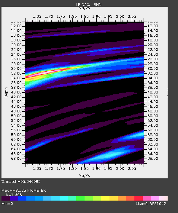
| Estimated Moho Depth: |
31.25 km |
| Estimated Crust Vp/Vs: |
1.70 |
| Assumed Crust Vp: |
6.279 km/s |
| Estimated Crust Vs: |
3.704 km/s |
| Estimated Crust Poisson's Ratio: |
0.23 |
|
| Radial Match: |
95.646095 % |
| Radial Bump: |
373 |
| Transverse Match: |
86.08286 % |
| Transverse Bump: |
400 |
| SOD ConfigId: |
346946 |
| Insert Time: |
2011-07-04 09:00:59.635 +0000 |
| GWidth: |
2.5 |
| Max Bumps: |
400 |
| Tol: |
0.001 |
|

Signal To Noise
| Channel | StoN | STA | LTA |
| LB:DAC: :BHZ:20110102T20:32:18.610994Z | 3.1799786 | 7.1951507E-7 | 2.2626412E-7 |
| LB:DAC: :BHN:20110102T20:32:18.610994Z | 0.79098076 | 1.7411645E-7 | 2.2012729E-7 |
| LB:DAC: :BHE:20110102T20:32:18.610994Z | 0.97850907 | 2.6712476E-7 | 2.729916E-7 |
| Arrivals |
| Ps | 3.5 SECOND |
| PpPs | 13 SECOND |
| PsPs/PpSs | 17 SECOND |


