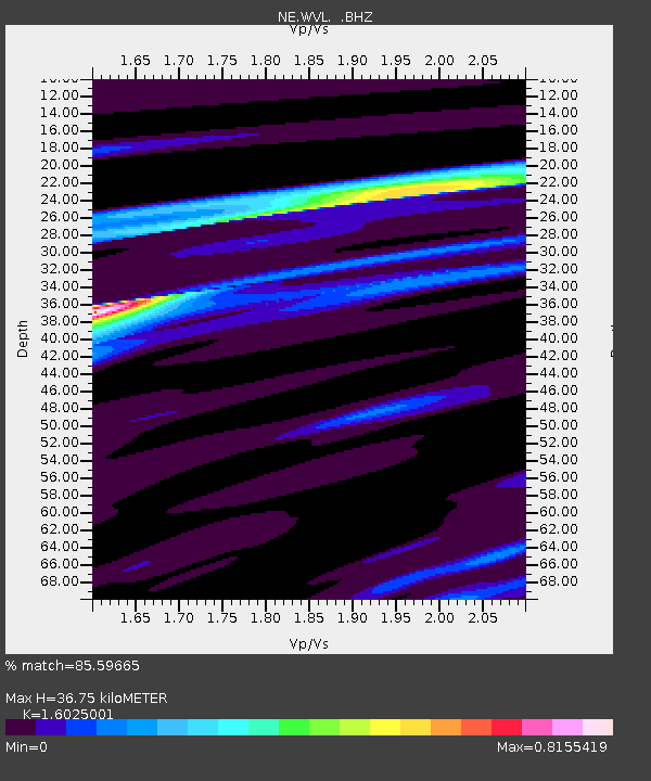
WVL Waterville, ME - Earthquake Result Viewer

Earthquake location: Near Coast Of Central Chile
Earthquake latitude/longitude: -38.4/-73.3
Earthquake time(UTC): 2011/01/02 (002) 20:20:17 GMT
Earthquake Depth: 24 km
Earthquake Magnitude: 6.6 MB, 7.1 MS, 7.1 MW, 7.0 MW
Earthquake Catalog/Contributor: WHDF/NEIC
Network: NE New England Seismic Network
Station: WVL Waterville, ME
Lat/Lon: 44.56 N/69.66 W
Elevation: 85 m
Distance: 82.6 deg
Az: 2.643 deg
Baz: 182.908 deg
Ray Param: 0.04674438
Estimated Moho Depth: 36.75 km
Estimated Crust Vp/Vs: 1.60
Assumed Crust Vp: 6.419 km/s
Estimated Crust Vs: 4.006 km/s
Estimated Crust Poisson's Ratio: 0.18
Radial Match: 85.59665 %
Radial Bump: 293
Transverse Match: 67.933846 %
Transverse Bump: 400
SOD ConfigId: 346946
Insert Time: 2011-07-04 09:04:28.741 +0000
GWidth: 2.5
Max Bumps: 400
Tol: 0.001

Signal To Noise

ChannelStoNSTALTA
NE:WVL: :BHZ:20110102T20:32:07.499971Z4.9878912.6988912E-65.4108864E-7
NE:WVL: :BHN:20110102T20:32:07.499971Z2.66569549.90842E-73.7170113E-7
NE:WVL: :BHE:20110102T20:32:07.499971Z0.823148252.5456262E-73.092549E-7
Arrivals
Ps3.6 SECOND
PpPs14 SECOND
PsPs/PpSs18 SECOND