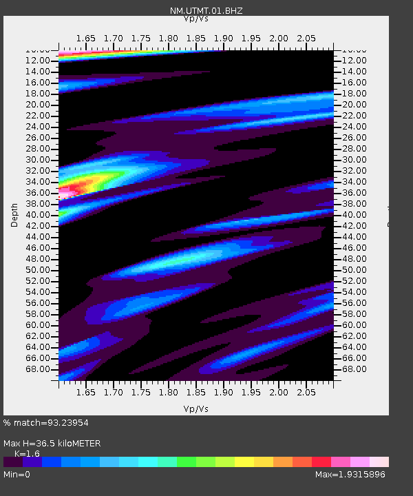
UTMT Martin, TN - Earthquake Result Viewer
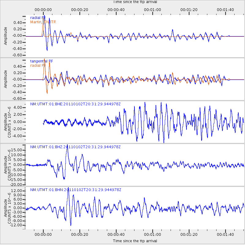
Earthquake location: Near Coast Of Central Chile
Earthquake latitude/longitude: -38.4/-73.3
Earthquake time(UTC): 2011/01/02 (002) 20:20:17 GMT
Earthquake Depth: 24 km
Earthquake Magnitude: 6.6 MB, 7.1 MS, 7.1 MW, 7.0 MW
Earthquake Catalog/Contributor: WHDF/NEIC
Network: NM Cooperative New Madrid Seismic Network
Station: UTMT Martin, TN
Lat/Lon: 36.35 N/88.86 W
Elevation: 110 m
Distance: 75.7 deg
Az: 347.105 deg
Baz: 167.448 deg
Ray Param: 0.051457632
Estimated Moho Depth: 36.5 km
Estimated Crust Vp/Vs: 1.60
Assumed Crust Vp: 6.444 km/s
Estimated Crust Vs: 4.027 km/s
Estimated Crust Poisson's Ratio: 0.18
Radial Match: 93.23954 %
Radial Bump: 400
Transverse Match: 90.00744 %
Transverse Bump: 400
SOD ConfigId: 346946
Insert Time: 2011-07-04 09:07:11.861 +0000
GWidth: 2.5
Max Bumps: 400
Tol: 0.001

Signal To Noise

ChannelStoNSTALTA
NM:UTMT:01:BHZ:20110102T20:31:29.944978Z6.60407072.6073249E-63.948057E-7
NM:UTMT:01:BHN:20110102T20:31:29.944978Z2.38836171.4422128E-66.0385025E-7
NM:UTMT:01:BHE:20110102T20:31:29.944978Z0.776459633.909804E-75.035425E-7
Arrivals
Ps3.5 SECOND
PpPs14 SECOND
PsPs/PpSs18 SECOND