You are here: Home > Network List > TA - USArray Transportable Network (new EarthScope stations) Stations List
> Station S22A 4UR Ranch, Creede, CO, USA > Earthquake Result Viewer
S22A 4UR Ranch, Creede, CO, USA - Earthquake Result Viewer
| Earthquake location: |
Near Coast Of Central Chile |
| Earthquake latitude/longitude: |
-38.4/-73.3 |
| Earthquake time(UTC): |
2011/01/02 (002) 20:20:17 GMT |
| Earthquake Depth: |
24 km |
| Earthquake Magnitude: |
6.6 MB, 7.1 MS, 7.1 MW, 7.0 MW |
| Earthquake Catalog/Contributor: |
WHDF/NEIC |
|
| Network: |
TA USArray Transportable Network (new EarthScope stations) |
| Station: |
S22A 4UR Ranch, Creede, CO, USA |
| Lat/Lon: |
37.75 N/106.83 W |
| Elevation: |
2626 m |
|
| Distance: |
81.8 deg |
| Az: |
333.761 deg |
| Baz: |
153.993 deg |
| Ray Param: |
0.04732015 |
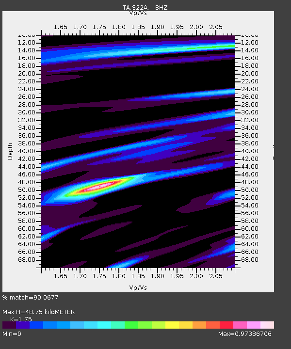
| Estimated Moho Depth: |
48.75 km |
| Estimated Crust Vp/Vs: |
1.75 |
| Assumed Crust Vp: |
6.159 km/s |
| Estimated Crust Vs: |
3.519 km/s |
| Estimated Crust Poisson's Ratio: |
0.26 |
|
| Radial Match: |
90.0677 % |
| Radial Bump: |
365 |
| Transverse Match: |
93.245026 % |
| Transverse Bump: |
347 |
| SOD ConfigId: |
346946 |
| Insert Time: |
2011-07-04 09:11:34.455 +0000 |
| GWidth: |
2.5 |
| Max Bumps: |
400 |
| Tol: |
0.001 |
|

Signal To Noise
| Channel | StoN | STA | LTA |
| TA:S22A: :BHZ:20110102T20:32:03.17502Z | 5.3050127 | 1.15138E-6 | 2.1703624E-7 |
| TA:S22A: :BHN:20110102T20:32:03.17502Z | 1.5629716 | 2.7394003E-7 | 1.7526874E-7 |
| TA:S22A: :BHE:20110102T20:32:03.17502Z | 0.98537934 | 1.597913E-7 | 1.6216222E-7 |
| Arrivals |
| Ps | 6.1 SECOND |
| PpPs | 21 SECOND |
| PsPs/PpSs | 27 SECOND |


