You are here: Home > Network List > TA - USArray Transportable Network (new EarthScope stations) Stations List
> Station 331A San Angelo, TX, USA > Earthquake Result Viewer
331A San Angelo, TX, USA - Earthquake Result Viewer
| Earthquake location: |
Near Coast Of Central Chile |
| Earthquake latitude/longitude: |
-38.4/-73.3 |
| Earthquake time(UTC): |
2011/01/02 (002) 20:20:17 GMT |
| Earthquake Depth: |
24 km |
| Earthquake Magnitude: |
6.6 MB, 7.1 MS, 7.1 MW, 7.0 MW |
| Earthquake Catalog/Contributor: |
WHDF/NEIC |
|
| Network: |
TA USArray Transportable Network (new EarthScope stations) |
| Station: |
331A San Angelo, TX, USA |
| Lat/Lon: |
31.31 N/100.43 W |
| Elevation: |
615 m |
|
| Distance: |
73.8 deg |
| Az: |
336.04 deg |
| Baz: |
158.098 deg |
| Ray Param: |
0.052754354 |
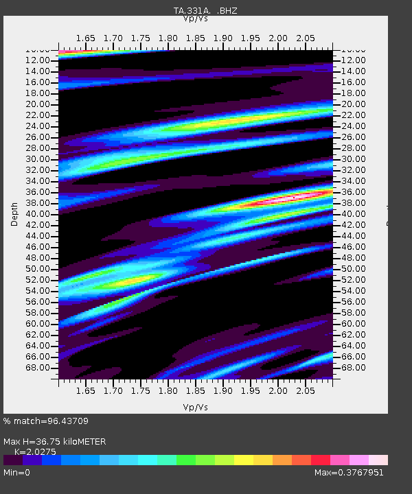
| Estimated Moho Depth: |
36.75 km |
| Estimated Crust Vp/Vs: |
2.03 |
| Assumed Crust Vp: |
6.38 km/s |
| Estimated Crust Vs: |
3.147 km/s |
| Estimated Crust Poisson's Ratio: |
0.34 |
|
| Radial Match: |
96.43709 % |
| Radial Bump: |
336 |
| Transverse Match: |
91.11331 % |
| Transverse Bump: |
400 |
| SOD ConfigId: |
346946 |
| Insert Time: |
2011-07-04 09:17:30.430 +0000 |
| GWidth: |
2.5 |
| Max Bumps: |
400 |
| Tol: |
0.001 |
|
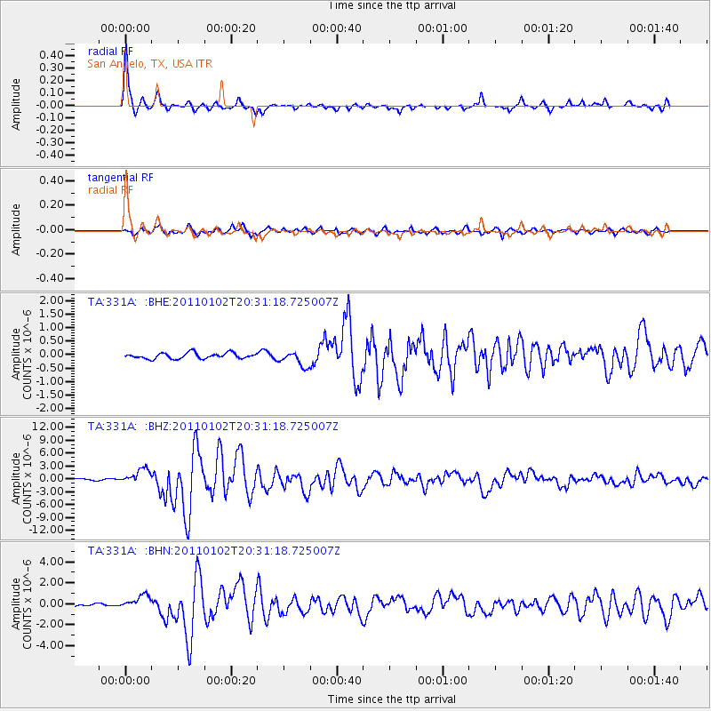
Signal To Noise
| Channel | StoN | STA | LTA |
| TA:331A: :BHZ:20110102T20:31:18.725007Z | 9.6918125 | 1.7531453E-6 | 1.8088932E-7 |
| TA:331A: :BHN:20110102T20:31:18.725007Z | 6.7953825 | 6.4957084E-7 | 9.559003E-8 |
| TA:331A: :BHE:20110102T20:31:18.725007Z | 2.68078 | 2.8197957E-7 | 1.0518564E-7 |
| Arrivals |
| Ps | 6.1 SECOND |
| PpPs | 17 SECOND |
| PsPs/PpSs | 23 SECOND |


