You are here: Home > Network List > TA - USArray Transportable Network (new EarthScope stations) Stations List
> Station Y30A Stafford Cattle Company, Roaring Springs, TX, USA > Earthquake Result Viewer
Y30A Stafford Cattle Company, Roaring Springs, TX, USA - Earthquake Result Viewer
| Earthquake location: |
Near Coast Of Central Chile |
| Earthquake latitude/longitude: |
-38.4/-73.3 |
| Earthquake time(UTC): |
2011/01/02 (002) 20:20:17 GMT |
| Earthquake Depth: |
24 km |
| Earthquake Magnitude: |
6.6 MB, 7.1 MS, 7.1 MW, 7.0 MW |
| Earthquake Catalog/Contributor: |
WHDF/NEIC |
|
| Network: |
TA USArray Transportable Network (new EarthScope stations) |
| Station: |
Y30A Stafford Cattle Company, Roaring Springs, TX, USA |
| Lat/Lon: |
33.88 N/100.90 W |
| Elevation: |
812 m |
|
| Distance: |
76.3 deg |
| Az: |
336.648 deg |
| Baz: |
158.002 deg |
| Ray Param: |
0.051063832 |
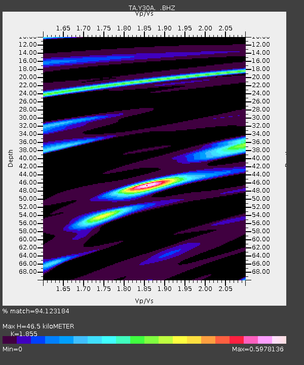
| Estimated Moho Depth: |
46.5 km |
| Estimated Crust Vp/Vs: |
1.86 |
| Assumed Crust Vp: |
6.426 km/s |
| Estimated Crust Vs: |
3.464 km/s |
| Estimated Crust Poisson's Ratio: |
0.30 |
|
| Radial Match: |
94.123184 % |
| Radial Bump: |
326 |
| Transverse Match: |
87.47325 % |
| Transverse Bump: |
400 |
| SOD ConfigId: |
346946 |
| Insert Time: |
2011-07-04 09:18:24.436 +0000 |
| GWidth: |
2.5 |
| Max Bumps: |
400 |
| Tol: |
0.001 |
|

Signal To Noise
| Channel | StoN | STA | LTA |
| TA:Y30A: :BHZ:20110102T20:31:33.249971Z | 6.988666 | 1.9187548E-6 | 2.7455238E-7 |
| TA:Y30A: :BHN:20110102T20:31:33.249971Z | 3.3621948 | 6.3754226E-7 | 1.8962085E-7 |
| TA:Y30A: :BHE:20110102T20:31:33.249971Z | 0.86397535 | 1.9405779E-7 | 2.2461033E-7 |
| Arrivals |
| Ps | 6.4 SECOND |
| PpPs | 20 SECOND |
| PsPs/PpSs | 26 SECOND |


