You are here: Home > Network List > TA - USArray Transportable Network (new EarthScope stations) Stations List
> Station Y31A Rekieta Farm, Paducah, TX, USA > Earthquake Result Viewer
Y31A Rekieta Farm, Paducah, TX, USA - Earthquake Result Viewer

| Earthquake location: |
Near Coast Of Central Chile |
| Earthquake latitude/longitude: |
-38.4/-73.3 |
| Earthquake time(UTC): |
2011/01/02 (002) 20:20:17 GMT |
| Earthquake Depth: |
24 km |
| Earthquake Magnitude: |
6.6 MB, 7.1 MS, 7.1 MW, 7.0 MW |
| Earthquake Catalog/Contributor: |
WHDF/NEIC |
|
| Network: |
TA USArray Transportable Network (new EarthScope stations) |
| Station: |
Y31A Rekieta Farm, Paducah, TX, USA |
| Lat/Lon: |
33.96 N/100.26 W |
| Elevation: |
530 m |
|
| Distance: |
76.2 deg |
| Az: |
337.187 deg |
| Baz: |
158.484 deg |
| Ray Param: |
0.051141832 |
| Estimated Moho Depth: |
28.0 km |
| Estimated Crust Vp/Vs: |
2.09 |
| Assumed Crust Vp: |
6.426 km/s |
| Estimated Crust Vs: |
3.082 km/s |
| Estimated Crust Poisson's Ratio: |
0.35 |
|
| Radial Match: |
94.23601 % |
| Radial Bump: |
280 |
| Transverse Match: |
81.42847 % |
| Transverse Bump: |
400 |
| SOD ConfigId: |
346946 |
| Insert Time: |
2011-07-04 09:19:15.280 +0000 |
| GWidth: |
2.5 |
| Max Bumps: |
400 |
| Tol: |
0.001 |
|
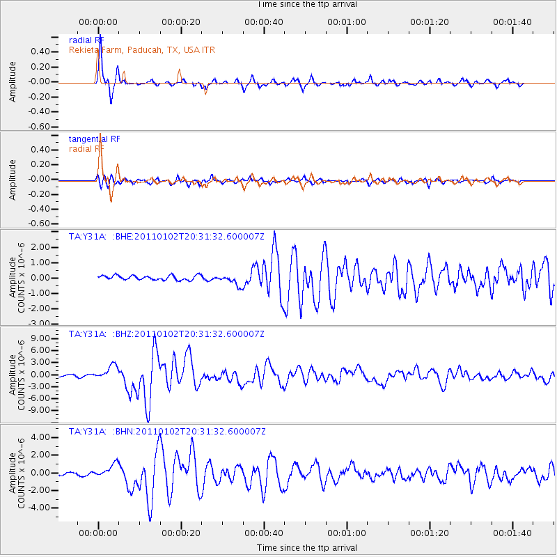
Signal To Noise
| Channel | StoN | STA | LTA |
| TA:Y31A: :BHZ:20110102T20:31:32.600007Z | 7.5342565 | 1.8576936E-6 | 2.465663E-7 |
| TA:Y31A: :BHN:20110102T20:31:32.600007Z | 5.3873663 | 8.289028E-7 | 1.5386048E-7 |
| TA:Y31A: :BHE:20110102T20:31:32.600007Z | 2.67716 | 3.796118E-7 | 1.4179646E-7 |
| Arrivals |
| Ps | 4.9 SECOND |
| PpPs | 13 SECOND |
| PsPs/PpSs | 18 SECOND |


