You are here: Home > Network List > GS - US Geological Survey Networks Stations List
> Station DEC12 Boyd Road Surface Site > Earthquake Result Viewer
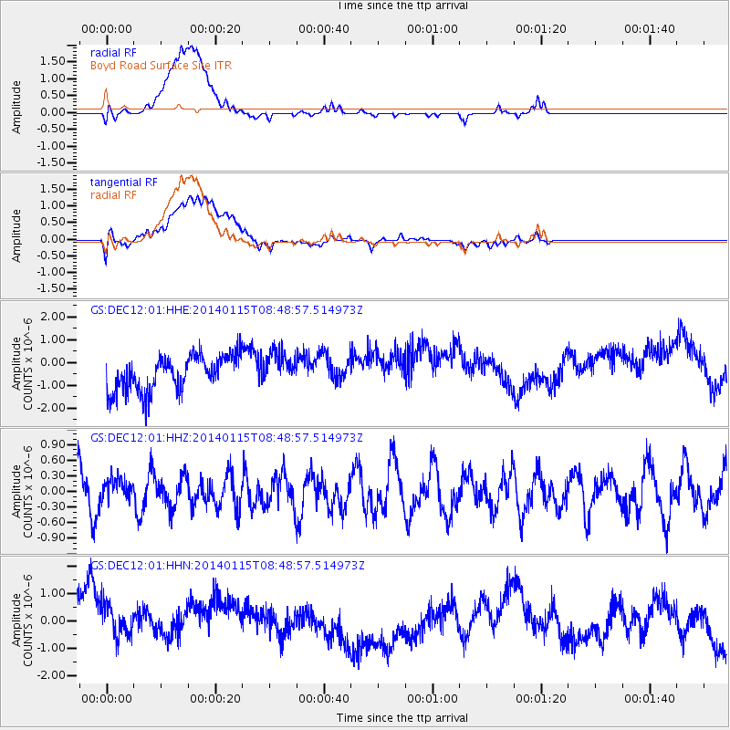
DEC12 Boyd Road Surface Site - Earthquake Result Viewer
*The percent match for this event was below the threshold and hence no stack was calculated.
| Earthquake location: |
San Juan Province, Argentina |
| Earthquake latitude/longitude: |
-31.1/-68.2 |
| Earthquake time(UTC): |
2014/01/15 (015) 08:38:08 GMT |
| Earthquake Depth: |
103 km |
| Earthquake Magnitude: |
5.2 MW |
| Earthquake Catalog/Contributor: |
ISC/ISC |
|
| Network: |
GS US Geological Survey Networks |
| Station: |
DEC12 Boyd Road Surface Site |
| Lat/Lon: |
39.91 N/88.91 W |
| Elevation: |
208 m |
|
| Distance: |
73.2 deg |
| Az: |
343.484 deg |
| Baz: |
161.523 deg |
| Ray Param: |
$rayparam |
*The percent match for this event was below the threshold and hence was not used in the summary stack. |
|
| Radial Match: |
25.611418 % |
| Radial Bump: |
400 |
| Transverse Match: |
21.176056 % |
| Transverse Bump: |
400 |
| SOD ConfigId: |
3390531 |
| Insert Time: |
2019-04-10 00:13:02.429 +0000 |
| GWidth: |
2.5 |
| Max Bumps: |
400 |
| Tol: |
0.001 |
|
Signal To Noise
| Channel | StoN | STA | LTA |
| GS:DEC12:01:HHZ:20140115T08:48:57.514973Z | 0.46766266 | 2.0214007E-7 | 4.322348E-7 |
| GS:DEC12:01:HHN:20140115T08:48:57.514973Z | 0.80002797 | 1.24382E-6 | 1.5547205E-6 |
| GS:DEC12:01:HHE:20140115T08:48:57.514973Z | 0.9572696 | 7.315182E-7 | 7.6417155E-7 |
| Arrivals |
| Ps | |
| PpPs | |
| PsPs/PpSs | |


