You are here: Home > Network List > TA - USArray Transportable Network (new EarthScope stations) Stations List
> Station G28A Parade, SD, USA > Earthquake Result Viewer
G28A Parade, SD, USA - Earthquake Result Viewer
| Earthquake location: |
Near Coast Of Central Chile |
| Earthquake latitude/longitude: |
-38.4/-73.3 |
| Earthquake time(UTC): |
2011/01/02 (002) 20:20:17 GMT |
| Earthquake Depth: |
24 km |
| Earthquake Magnitude: |
6.6 MB, 7.1 MS, 7.1 MW, 7.0 MW |
| Earthquake Catalog/Contributor: |
WHDF/NEIC |
|
| Network: |
TA USArray Transportable Network (new EarthScope stations) |
| Station: |
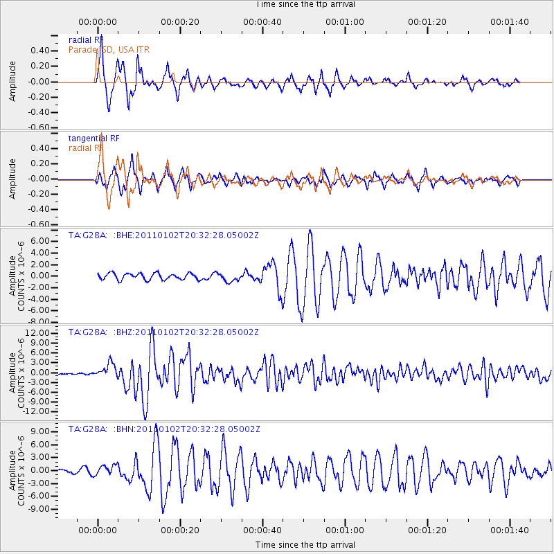
G28A Parade, SD, USA |
| Lat/Lon: |
45.07 N/100.92 W |
| Elevation: |
709 m |
|
| Distance: |
86.7 deg |
| Az: |
340.81 deg |
| Baz: |
158.609 deg |
| Ray Param: |
0.043839443 |
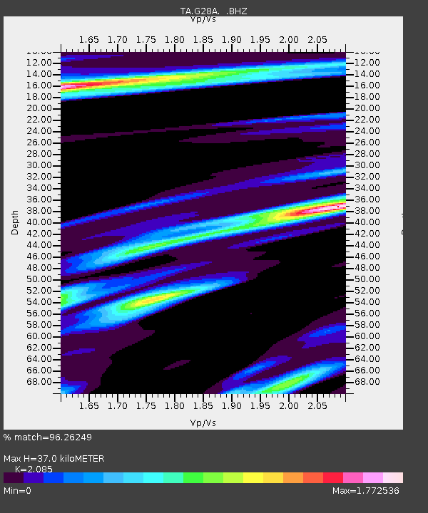
| Estimated Moho Depth: |
37.0 km |
| Estimated Crust Vp/Vs: |
2.09 |
| Assumed Crust Vp: |
6.53 km/s |
| Estimated Crust Vs: |
3.132 km/s |
| Estimated Crust Poisson's Ratio: |
0.35 |
|
| Radial Match: |
96.26249 % |
| Radial Bump: |
376 |
| Transverse Match: |
93.80526 % |
| Transverse Bump: |
400 |
| SOD ConfigId: |
346946 |
| Insert Time: |
2011-07-04 09:29:40.103 +0000 |
| GWidth: |
2.5 |
| Max Bumps: |
400 |
| Tol: |
0.001 |
|
Signal To Noise
| Channel | StoN | STA | LTA |
| TA:G28A: :BHZ:20110102T20:32:28.05002Z | 12.839986 | 2.3181701E-6 | 1.8054304E-7 |
| TA:G28A: :BHN:20110102T20:32:28.05002Z | 2.4984937 | 1.2040987E-6 | 4.819298E-7 |
| TA:G28A: :BHE:20110102T20:32:28.05002Z | 1.3526019 | 7.3719684E-7 | 5.450213E-7 |
| Arrivals |
| Ps | 6.3 SECOND |
| PpPs | 17 SECOND |
| PsPs/PpSs | 23 SECOND |


