You are here: Home > Network List > TA - USArray Transportable Network (new EarthScope stations) Stations List
> Station J27A Elkhorn Farm, Martin, SD, USA > Earthquake Result Viewer
J27A Elkhorn Farm, Martin, SD, USA - Earthquake Result Viewer
| Earthquake location: |
Near Coast Of Central Chile |
| Earthquake latitude/longitude: |
-38.4/-73.3 |
| Earthquake time(UTC): |
2011/01/02 (002) 20:20:17 GMT |
| Earthquake Depth: |
24 km |
| Earthquake Magnitude: |
6.6 MB, 7.1 MS, 7.1 MW, 7.0 MW |
| Earthquake Catalog/Contributor: |
WHDF/NEIC |
|
| Network: |
TA USArray Transportable Network (new EarthScope stations) |
| Station: |
J27A Elkhorn Farm, Martin, SD, USA |
| Lat/Lon: |
43.25 N/102.01 W |
| Elevation: |
1081 m |
|
| Distance: |
85.3 deg |
| Az: |
339.4 deg |
| Baz: |
157.753 deg |
| Ray Param: |
0.044841222 |
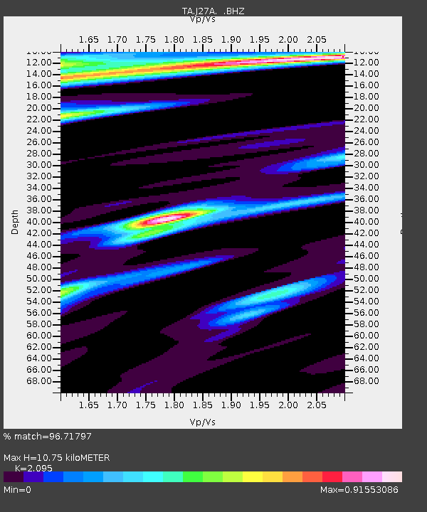
| Estimated Moho Depth: |
10.75 km |
| Estimated Crust Vp/Vs: |
2.10 |
| Assumed Crust Vp: |
6.483 km/s |
| Estimated Crust Vs: |
3.094 km/s |
| Estimated Crust Poisson's Ratio: |
0.35 |
|
| Radial Match: |
96.71797 % |
| Radial Bump: |
314 |
| Transverse Match: |
90.463905 % |
| Transverse Bump: |
377 |
| SOD ConfigId: |
346946 |
| Insert Time: |
2011-07-04 09:35:07.545 +0000 |
| GWidth: |
2.5 |
| Max Bumps: |
400 |
| Tol: |
0.001 |
|

Signal To Noise
| Channel | StoN | STA | LTA |
| TA:J27A: :BHZ:20110102T20:32:21.149995Z | 10.188698 | 2.311541E-6 | 2.2687306E-7 |
| TA:J27A: :BHN:20110102T20:32:21.149995Z | 1.0500752 | 3.844259E-7 | 3.6609367E-7 |
| TA:J27A: :BHE:20110102T20:32:21.149995Z | 1.9103473 | 9.58031E-7 | 5.014957E-7 |
| Arrivals |
| Ps | 1.9 SECOND |
| PpPs | 5.0 SECOND |
| PsPs/PpSs | 6.9 SECOND |


