You are here: Home > Network List > TA - USArray Transportable Network (new EarthScope stations) Stations List
> Station L30A Spencer Herefords Ranch, Brewster, NE, USA > Earthquake Result Viewer
L30A Spencer Herefords Ranch, Brewster, NE, USA - Earthquake Result Viewer
| Earthquake location: |
Near Coast Of Central Chile |
| Earthquake latitude/longitude: |
-38.4/-73.3 |
| Earthquake time(UTC): |
2011/01/02 (002) 20:20:17 GMT |
| Earthquake Depth: |
24 km |
| Earthquake Magnitude: |
6.6 MB, 7.1 MS, 7.1 MW, 7.0 MW |
| Earthquake Catalog/Contributor: |
WHDF/NEIC |
|
| Network: |
TA USArray Transportable Network (new EarthScope stations) |
| Station: |
L30A Spencer Herefords Ranch, Brewster, NE, USA |
| Lat/Lon: |
41.95 N/99.72 W |
| Elevation: |
782 m |
|
| Distance: |
83.5 deg |
| Az: |
340.502 deg |
| Baz: |
159.404 deg |
| Ray Param: |
0.046142276 |
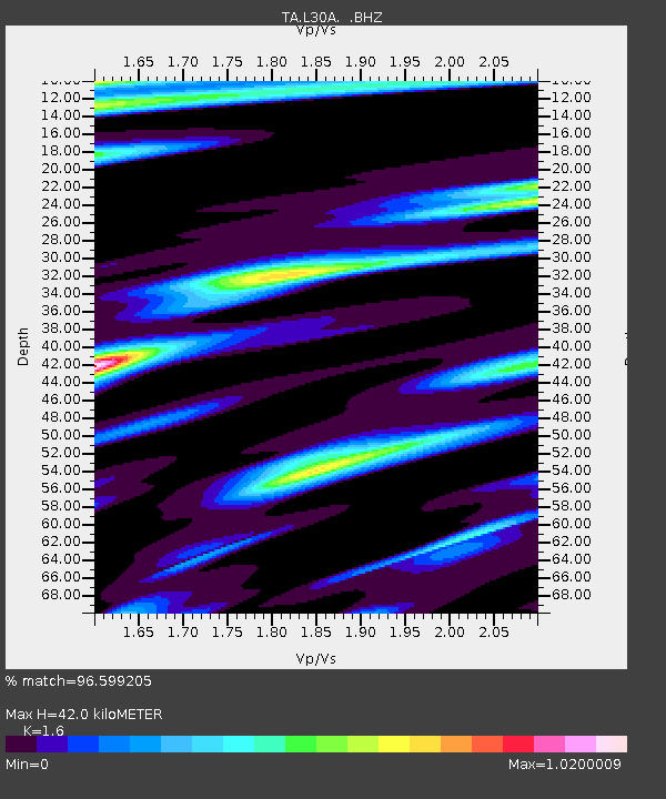
| Estimated Moho Depth: |
42.0 km |
| Estimated Crust Vp/Vs: |
1.60 |
| Assumed Crust Vp: |
6.53 km/s |
| Estimated Crust Vs: |
4.082 km/s |
| Estimated Crust Poisson's Ratio: |
0.18 |
|
| Radial Match: |
96.599205 % |
| Radial Bump: |
287 |
| Transverse Match: |
95.088264 % |
| Transverse Bump: |
333 |
| SOD ConfigId: |
346946 |
| Insert Time: |
2011-07-04 09:40:06.223 +0000 |
| GWidth: |
2.5 |
| Max Bumps: |
400 |
| Tol: |
0.001 |
|
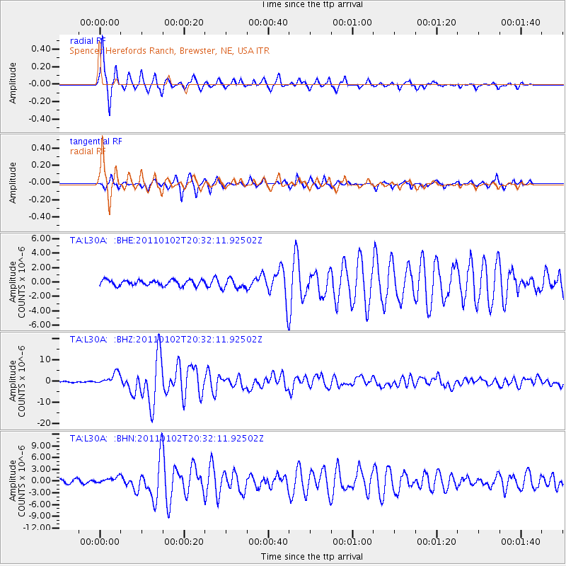
Signal To Noise
| Channel | StoN | STA | LTA |
| TA:L30A: :BHZ:20110102T20:32:11.92502Z | 14.7821245 | 2.8903935E-6 | 1.9553303E-7 |
| TA:L30A: :BHN:20110102T20:32:11.92502Z | 2.0809672 | 8.917928E-7 | 4.285473E-7 |
| TA:L30A: :BHE:20110102T20:32:11.92502Z | 1.8367591 | 6.928486E-7 | 3.7721256E-7 |
| Arrivals |
| Ps | 4.0 SECOND |
| PpPs | 16 SECOND |
| PsPs/PpSs | 20 SECOND |


