You are here: Home > Network List > TA - USArray Transportable Network (new EarthScope stations) Stations List
> Station I30A Oacoma, SD, USA > Earthquake Result Viewer
I30A Oacoma, SD, USA - Earthquake Result Viewer
| Earthquake location: |
Near Coast Of Central Chile |
| Earthquake latitude/longitude: |
-38.4/-73.3 |
| Earthquake time(UTC): |
2011/01/02 (002) 20:20:17 GMT |
| Earthquake Depth: |
24 km |
| Earthquake Magnitude: |
6.6 MB, 7.1 MS, 7.1 MW, 7.0 MW |
| Earthquake Catalog/Contributor: |
WHDF/NEIC |
|
| Network: |
TA USArray Transportable Network (new EarthScope stations) |
| Station: |
I30A Oacoma, SD, USA |
| Lat/Lon: |
43.91 N/99.43 W |
| Elevation: |
549 m |
|
| Distance: |
85.2 deg |
| Az: |
341.394 deg |
| Baz: |
159.691 deg |
| Ray Param: |
0.044887416 |
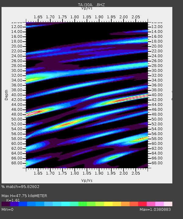
| Estimated Moho Depth: |
47.75 km |
| Estimated Crust Vp/Vs: |
1.61 |
| Assumed Crust Vp: |
6.53 km/s |
| Estimated Crust Vs: |
4.056 km/s |
| Estimated Crust Poisson's Ratio: |
0.19 |
|
| Radial Match: |
95.82802 % |
| Radial Bump: |
400 |
| Transverse Match: |
89.6256 % |
| Transverse Bump: |
400 |
| SOD ConfigId: |
346946 |
| Insert Time: |
2011-07-04 09:43:21.717 +0000 |
| GWidth: |
2.5 |
| Max Bumps: |
400 |
| Tol: |
0.001 |
|

Signal To Noise
| Channel | StoN | STA | LTA |
| TA:I30A: :BHZ:20110102T20:32:20.824983Z | 7.590425 | 2.0704892E-6 | 2.7277645E-7 |
| TA:I30A: :BHN:20110102T20:32:20.824983Z | 2.9250124 | 9.1386613E-7 | 3.1243152E-7 |
| TA:I30A: :BHE:20110102T20:32:20.824983Z | 1.4185379 | 3.636813E-7 | 2.5637758E-7 |
| Arrivals |
| Ps | 4.6 SECOND |
| PpPs | 19 SECOND |
| PsPs/PpSs | 23 SECOND |


