You are here: Home > Network List > TA - USArray Transportable Network (new EarthScope stations) Stations List
> Station O48A Farmland, IN, USA > Earthquake Result Viewer
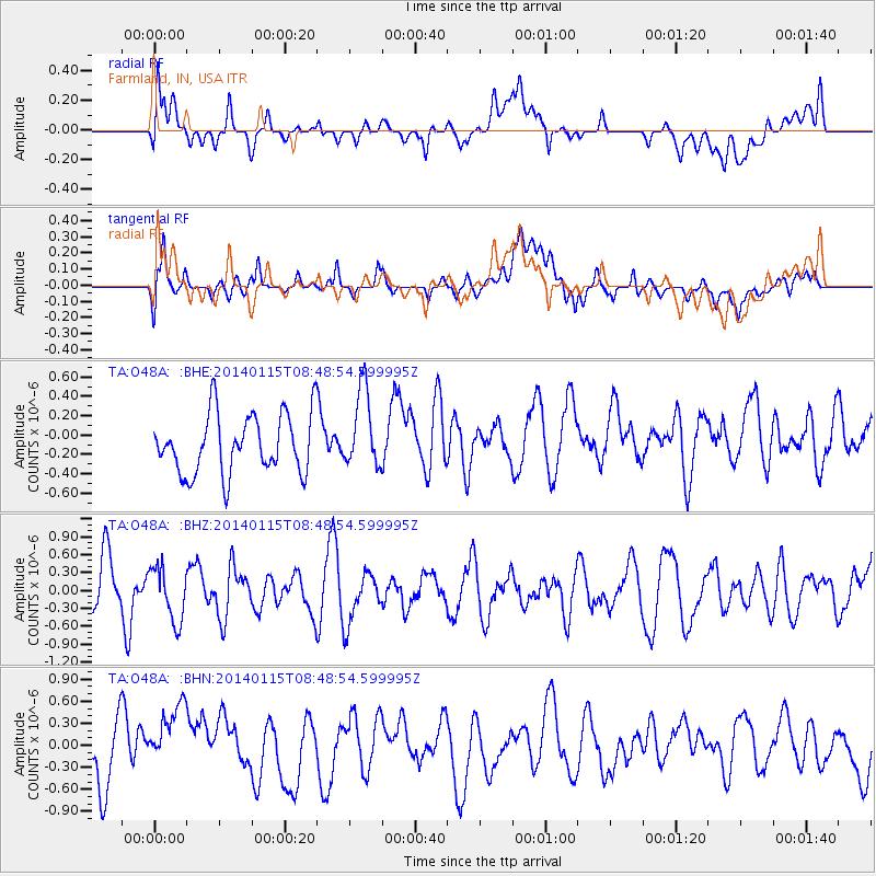
O48A Farmland, IN, USA - Earthquake Result Viewer
*The percent match for this event was below the threshold and hence no stack was calculated.
| Earthquake location: |
San Juan Province, Argentina |
| Earthquake latitude/longitude: |
-31.1/-68.2 |
| Earthquake time(UTC): |
2014/01/15 (015) 08:38:08 GMT |
| Earthquake Depth: |
103 km |
| Earthquake Magnitude: |
5.2 MW |
| Earthquake Catalog/Contributor: |
ISC/ISC |
|
| Network: |
TA USArray Transportable Network (new EarthScope stations) |
| Station: |
O48A Farmland, IN, USA |
| Lat/Lon: |
40.26 N/85.16 W |
| Elevation: |
300 m |
|
| Distance: |
72.7 deg |
| Az: |
346.471 deg |
| Baz: |
164.803 deg |
| Ray Param: |
$rayparam |
*The percent match for this event was below the threshold and hence was not used in the summary stack. |
|
| Radial Match: |
54.01294 % |
| Radial Bump: |
400 |
| Transverse Match: |
60.205982 % |
| Transverse Bump: |
400 |
| SOD ConfigId: |
3390531 |
| Insert Time: |
2019-04-10 00:15:12.288 +0000 |
| GWidth: |
2.5 |
| Max Bumps: |
400 |
| Tol: |
0.001 |
|
Signal To Noise
| Channel | StoN | STA | LTA |
| TA:O48A: :BHZ:20140115T08:48:54.599995Z | 1.0903133 | 4.5480957E-7 | 4.171366E-7 |
| TA:O48A: :BHN:20140115T08:48:54.599995Z | 1.3040347 | 6.0290444E-7 | 4.623377E-7 |
| TA:O48A: :BHE:20140115T08:48:54.599995Z | 1.3421226 | 4.098531E-7 | 3.0537683E-7 |
| Arrivals |
| Ps | |
| PpPs | |
| PsPs/PpSs | |


