You are here: Home > Network List > TA - USArray Transportable Network (new EarthScope stations) Stations List
> Station X32A Elmer, OK, USA > Earthquake Result Viewer
X32A Elmer, OK, USA - Earthquake Result Viewer
| Earthquake location: |
Near Coast Of Central Chile |
| Earthquake latitude/longitude: |
-38.4/-73.3 |
| Earthquake time(UTC): |
2011/01/02 (002) 20:20:17 GMT |
| Earthquake Depth: |
24 km |
| Earthquake Magnitude: |
6.6 MB, 7.1 MS, 7.1 MW, 7.0 MW |
| Earthquake Catalog/Contributor: |
WHDF/NEIC |
|
| Network: |
TA USArray Transportable Network (new EarthScope stations) |
| Station: |
X32A Elmer, OK, USA |
| Lat/Lon: |
34.42 N/99.29 W |
| Elevation: |
401 m |
|
| Distance: |
76.3 deg |
| Az: |
338.134 deg |
| Baz: |
159.255 deg |
| Ray Param: |
0.051051248 |
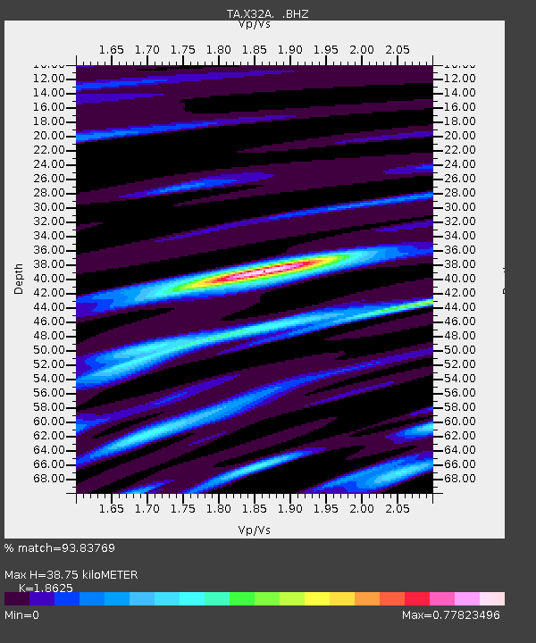
| Estimated Moho Depth: |
38.75 km |
| Estimated Crust Vp/Vs: |
1.86 |
| Assumed Crust Vp: |
6.315 km/s |
| Estimated Crust Vs: |
3.391 km/s |
| Estimated Crust Poisson's Ratio: |
0.30 |
|
| Radial Match: |
93.83769 % |
| Radial Bump: |
373 |
| Transverse Match: |
85.92601 % |
| Transverse Bump: |
400 |
| SOD ConfigId: |
346946 |
| Insert Time: |
2011-07-04 09:45:44.096 +0000 |
| GWidth: |
2.5 |
| Max Bumps: |
400 |
| Tol: |
0.001 |
|

Signal To Noise
| Channel | StoN | STA | LTA |
| TA:X32A: :BHZ:20110102T20:31:33.374971Z | 14.957833 | 1.9270783E-6 | 1.2883406E-7 |
| TA:X32A: :BHN:20110102T20:31:33.374971Z | 5.698605 | 7.684465E-7 | 1.3484818E-7 |
| TA:X32A: :BHE:20110102T20:31:33.374971Z | 1.0190953 | 2.8477368E-7 | 2.7943773E-7 |
| Arrivals |
| Ps | 5.4 SECOND |
| PpPs | 17 SECOND |
| PsPs/PpSs | 23 SECOND |


