You are here: Home > Network List > TA - USArray Transportable Network (new EarthScope stations) Stations List
> Station U33A Lingo Farm, Meno, OK, USA > Earthquake Result Viewer
U33A Lingo Farm, Meno, OK, USA - Earthquake Result Viewer
| Earthquake location: |
Near Coast Of Central Chile |
| Earthquake latitude/longitude: |
-38.4/-73.3 |
| Earthquake time(UTC): |
2011/01/02 (002) 20:20:17 GMT |
| Earthquake Depth: |
24 km |
| Earthquake Magnitude: |
6.6 MB, 7.1 MS, 7.1 MW, 7.0 MW |
| Earthquake Catalog/Contributor: |
WHDF/NEIC |
|
| Network: |
TA USArray Transportable Network (new EarthScope stations) |
| Station: |
U33A Lingo Farm, Meno, OK, USA |
| Lat/Lon: |
36.43 N/98.11 W |
| Elevation: |
393 m |
|
| Distance: |
77.9 deg |
| Az: |
339.767 deg |
| Baz: |
160.296 deg |
| Ray Param: |
0.050004907 |
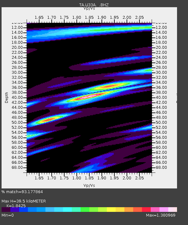
| Estimated Moho Depth: |
39.5 km |
| Estimated Crust Vp/Vs: |
1.84 |
| Assumed Crust Vp: |
6.426 km/s |
| Estimated Crust Vs: |
3.488 km/s |
| Estimated Crust Poisson's Ratio: |
0.29 |
|
| Radial Match: |
93.177864 % |
| Radial Bump: |
361 |
| Transverse Match: |
91.9806 % |
| Transverse Bump: |
338 |
| SOD ConfigId: |
346946 |
| Insert Time: |
2011-07-04 09:46:09.464 +0000 |
| GWidth: |
2.5 |
| Max Bumps: |
400 |
| Tol: |
0.001 |
|
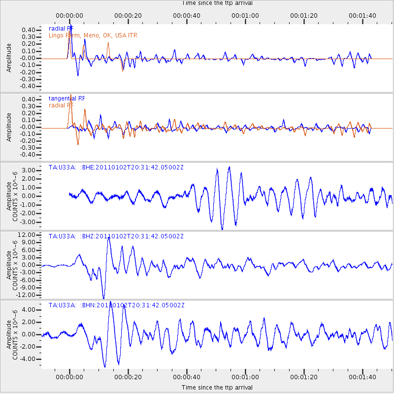
Signal To Noise
| Channel | StoN | STA | LTA |
| TA:U33A: :BHZ:20110102T20:31:42.05002Z | 8.404549 | 2.2060854E-6 | 2.6248708E-7 |
| TA:U33A: :BHN:20110102T20:31:42.05002Z | 3.3461628 | 9.66015E-7 | 2.8869334E-7 |
| TA:U33A: :BHE:20110102T20:31:42.05002Z | 1.8362544 | 6.8419655E-7 | 3.7260446E-7 |
| Arrivals |
| Ps | 5.3 SECOND |
| PpPs | 17 SECOND |
| PsPs/PpSs | 22 SECOND |


