You are here: Home > Network List > TA - USArray Transportable Network (new EarthScope stations) Stations List
> Station Z34A Collier Ranch, Chico, TX, USA > Earthquake Result Viewer
Z34A Collier Ranch, Chico, TX, USA - Earthquake Result Viewer
| Earthquake location: |
Near Coast Of Central Chile |
| Earthquake latitude/longitude: |
-38.4/-73.3 |
| Earthquake time(UTC): |
2011/01/02 (002) 20:20:17 GMT |
| Earthquake Depth: |
24 km |
| Earthquake Magnitude: |
6.6 MB, 7.1 MS, 7.1 MW, 7.0 MW |
| Earthquake Catalog/Contributor: |
WHDF/NEIC |
|
| Network: |
TA USArray Transportable Network (new EarthScope stations) |
| Station: |
Z34A Collier Ranch, Chico, TX, USA |
| Lat/Lon: |
33.37 N/97.92 W |
| Elevation: |
341 m |
|
| Distance: |
74.9 deg |
| Az: |
338.862 deg |
| Baz: |
160.196 deg |
| Ray Param: |
0.051971983 |
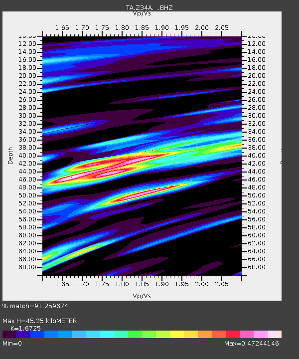
| Estimated Moho Depth: |
45.25 km |
| Estimated Crust Vp/Vs: |
1.67 |
| Assumed Crust Vp: |
6.38 km/s |
| Estimated Crust Vs: |
3.815 km/s |
| Estimated Crust Poisson's Ratio: |
0.22 |
|
| Radial Match: |
91.259674 % |
| Radial Bump: |
400 |
| Transverse Match: |
85.079636 % |
| Transverse Bump: |
369 |
| SOD ConfigId: |
346946 |
| Insert Time: |
2011-07-04 09:50:13.690 +0000 |
| GWidth: |
2.5 |
| Max Bumps: |
400 |
| Tol: |
0.001 |
|

Signal To Noise
| Channel | StoN | STA | LTA |
| TA:Z34A: :BHZ:20110102T20:31:25.499971Z | 12.477179 | 1.8393918E-6 | 1.4742048E-7 |
| TA:Z34A: :BHN:20110102T20:31:25.499971Z | 2.8117516 | 6.498214E-7 | 2.311091E-7 |
| TA:Z34A: :BHE:20110102T20:31:25.499971Z | 1.3465866 | 3.4144242E-7 | 2.535614E-7 |
| Arrivals |
| Ps | 4.9 SECOND |
| PpPs | 18 SECOND |
| PsPs/PpSs | 23 SECOND |


