You are here: Home > Network List > TA - USArray Transportable Network (new EarthScope stations) Stations List
> Station 237A Washetta, Montalba, TX, USA > Earthquake Result Viewer
237A Washetta, Montalba, TX, USA - Earthquake Result Viewer
| Earthquake location: |
Near Coast Of Central Chile |
| Earthquake latitude/longitude: |
-38.4/-73.3 |
| Earthquake time(UTC): |
2011/01/02 (002) 20:20:17 GMT |
| Earthquake Depth: |
24 km |
| Earthquake Magnitude: |
6.6 MB, 7.1 MS, 7.1 MW, 7.0 MW |
| Earthquake Catalog/Contributor: |
WHDF/NEIC |
|
| Network: |
TA USArray Transportable Network (new EarthScope stations) |
| Station: |
237A Washetta, Montalba, TX, USA |
| Lat/Lon: |
32.00 N/95.81 W |
| Elevation: |
126 m |
|
| Distance: |
73.1 deg |
| Az: |
340.146 deg |
| Baz: |
161.683 deg |
| Ray Param: |
0.053221915 |
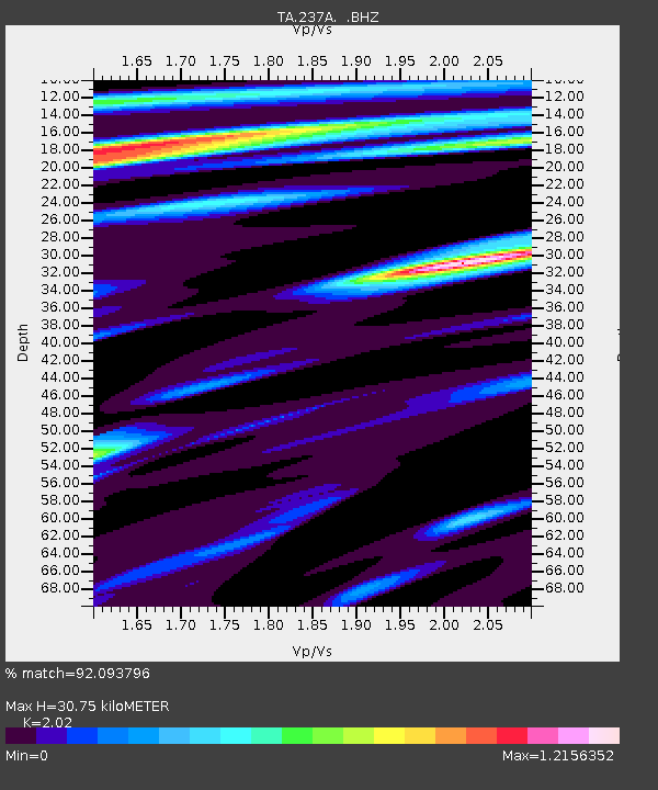
| Estimated Moho Depth: |
30.75 km |
| Estimated Crust Vp/Vs: |
2.02 |
| Assumed Crust Vp: |
6.245 km/s |
| Estimated Crust Vs: |
3.092 km/s |
| Estimated Crust Poisson's Ratio: |
0.34 |
|
| Radial Match: |
92.093796 % |
| Radial Bump: |
400 |
| Transverse Match: |
86.233 % |
| Transverse Bump: |
400 |
| SOD ConfigId: |
346946 |
| Insert Time: |
2011-07-04 09:59:01.487 +0000 |
| GWidth: |
2.5 |
| Max Bumps: |
400 |
| Tol: |
0.001 |
|

Signal To Noise
| Channel | StoN | STA | LTA |
| TA:237A: :BHZ:20110102T20:31:14.600007Z | 9.808857 | 2.4744272E-6 | 2.5226458E-7 |
| TA:237A: :BHN:20110102T20:31:14.600007Z | 3.0493045 | 1.0975223E-6 | 3.5992545E-7 |
| TA:237A: :BHE:20110102T20:31:14.600007Z | 1.2169051 | 4.872793E-7 | 4.0042505E-7 |
| Arrivals |
| Ps | 5.2 SECOND |
| PpPs | 14 SECOND |
| PsPs/PpSs | 20 SECOND |


