You are here: Home > Network List > TA - USArray Transportable Network (new EarthScope stations) Stations List
> Station 138A Matatall Enterprise, Big Sandy, TX, USA > Earthquake Result Viewer
138A Matatall Enterprise, Big Sandy, TX, USA - Earthquake Result Viewer
| Earthquake location: |
Near Coast Of Central Chile |
| Earthquake latitude/longitude: |
-38.4/-73.3 |
| Earthquake time(UTC): |
2011/01/02 (002) 20:20:17 GMT |
| Earthquake Depth: |
24 km |
| Earthquake Magnitude: |
6.6 MB, 7.1 MS, 7.1 MW, 7.0 MW |
| Earthquake Catalog/Contributor: |
WHDF/NEIC |
|
| Network: |
TA USArray Transportable Network (new EarthScope stations) |
| Station: |
138A Matatall Enterprise, Big Sandy, TX, USA |
| Lat/Lon: |
32.66 N/95.09 W |
| Elevation: |
143 m |
|
| Distance: |
73.5 deg |
| Az: |
340.963 deg |
| Baz: |
162.301 deg |
| Ray Param: |
0.05293429 |
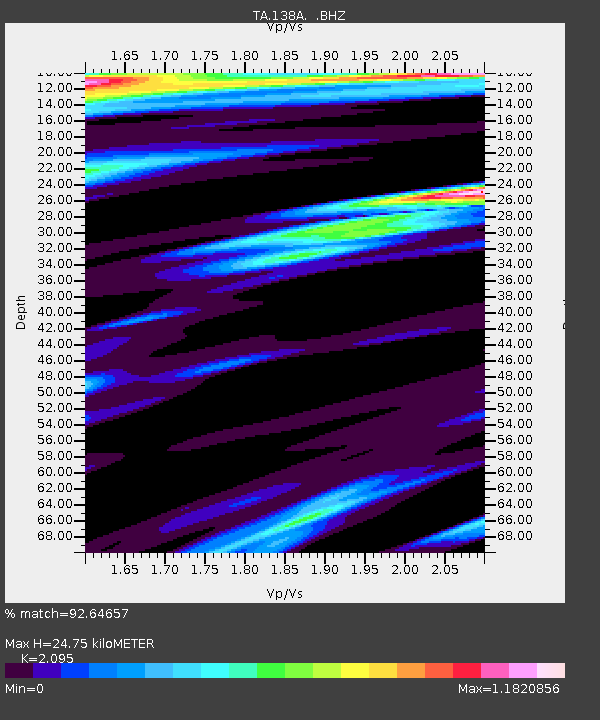
| Estimated Moho Depth: |
24.75 km |
| Estimated Crust Vp/Vs: |
2.10 |
| Assumed Crust Vp: |
6.245 km/s |
| Estimated Crust Vs: |
2.981 km/s |
| Estimated Crust Poisson's Ratio: |
0.35 |
|
| Radial Match: |
92.64657 % |
| Radial Bump: |
351 |
| Transverse Match: |
85.754654 % |
| Transverse Bump: |
400 |
| SOD ConfigId: |
346946 |
| Insert Time: |
2011-07-04 09:59:28.980 +0000 |
| GWidth: |
2.5 |
| Max Bumps: |
400 |
| Tol: |
0.001 |
|
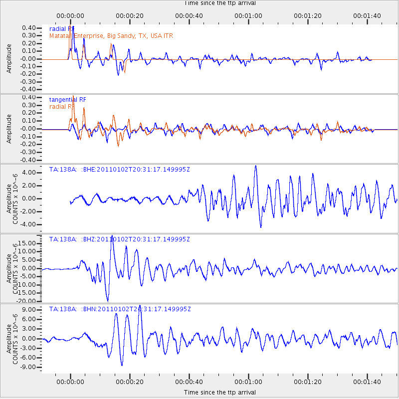
Signal To Noise
| Channel | StoN | STA | LTA |
| TA:138A: :BHZ:20110102T20:31:17.149995Z | 10.946093 | 2.4705487E-6 | 2.2570141E-7 |
| TA:138A: :BHN:20110102T20:31:17.149995Z | 1.6787515 | 7.9605553E-7 | 4.74195E-7 |
| TA:138A: :BHE:20110102T20:31:17.149995Z | 1.1180465 | 4.1894683E-7 | 3.747132E-7 |
| Arrivals |
| Ps | 4.5 SECOND |
| PpPs | 12 SECOND |
| PsPs/PpSs | 16 SECOND |


