You are here: Home > Network List > TA - USArray Transportable Network (new EarthScope stations) Stations List
> Station S34A Willow Spring Farm, Andover, KS, USA > Earthquake Result Viewer
S34A Willow Spring Farm, Andover, KS, USA - Earthquake Result Viewer
| Earthquake location: |
Near Coast Of Central Chile |
| Earthquake latitude/longitude: |
-38.4/-73.3 |
| Earthquake time(UTC): |
2011/01/02 (002) 20:20:17 GMT |
| Earthquake Depth: |
24 km |
| Earthquake Magnitude: |
6.6 MB, 7.1 MS, 7.1 MW, 7.0 MW |
| Earthquake Catalog/Contributor: |
WHDF/NEIC |
|
| Network: |
TA USArray Transportable Network (new EarthScope stations) |
| Station: |
S34A Willow Spring Farm, Andover, KS, USA |
| Lat/Lon: |
37.70 N/97.11 W |
| Elevation: |
373 m |
|
| Distance: |
78.8 deg |
| Az: |
340.967 deg |
| Baz: |
161.141 deg |
| Ray Param: |
0.04937297 |
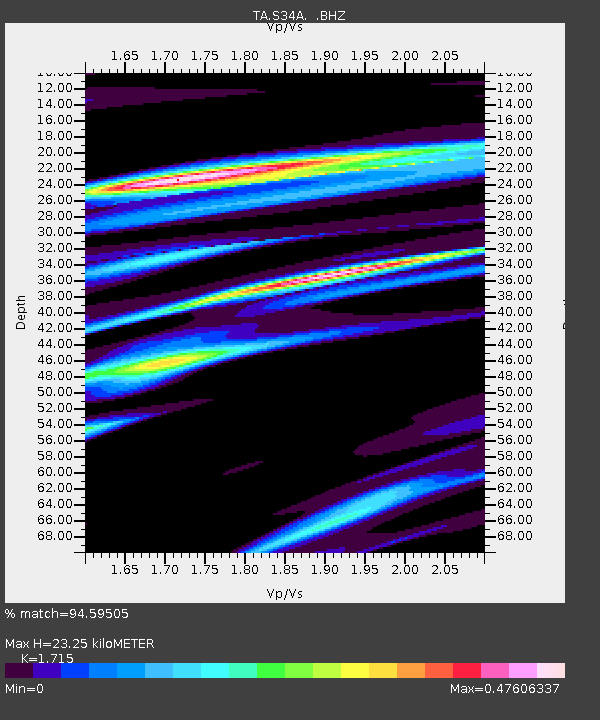
| Estimated Moho Depth: |
23.25 km |
| Estimated Crust Vp/Vs: |
1.72 |
| Assumed Crust Vp: |
6.483 km/s |
| Estimated Crust Vs: |
3.78 km/s |
| Estimated Crust Poisson's Ratio: |
0.24 |
|
| Radial Match: |
94.59505 % |
| Radial Bump: |
317 |
| Transverse Match: |
81.545204 % |
| Transverse Bump: |
400 |
| SOD ConfigId: |
346946 |
| Insert Time: |
2011-07-04 10:00:28.516 +0000 |
| GWidth: |
2.5 |
| Max Bumps: |
400 |
| Tol: |
0.001 |
|

Signal To Noise
| Channel | StoN | STA | LTA |
| TA:S34A: :BHZ:20110102T20:31:47.17502Z | 11.538218 | 2.1365906E-6 | 1.8517511E-7 |
| TA:S34A: :BHN:20110102T20:31:47.17502Z | 2.23554 | 7.2197196E-7 | 3.2295193E-7 |
| TA:S34A: :BHE:20110102T20:31:47.17502Z | 1.2125924 | 3.5507213E-7 | 2.928207E-7 |
| Arrivals |
| Ps | 2.6 SECOND |
| PpPs | 9.4 SECOND |
| PsPs/PpSs | 12 SECOND |


