You are here: Home > Network List > AZ - ANZA Regional Network Stations List
> Station FRD AZ.FRD > Earthquake Result Viewer
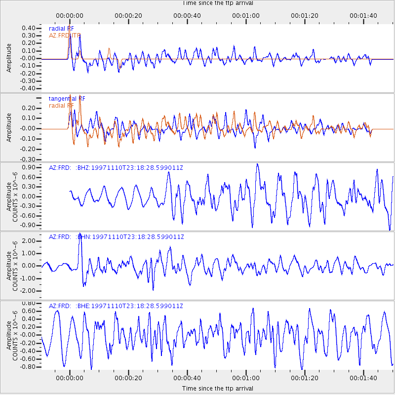
FRD AZ.FRD - Earthquake Result Viewer
*The percent match for this event was below the threshold and hence no stack was calculated.
| Earthquake location: |
Southeast Of Honshu, Japan |
| Earthquake latitude/longitude: |
31.2/140.5 |
| Earthquake time(UTC): |
1997/11/10 (314) 23:06:44 GMT |
| Earthquake Depth: |
86 km |
| Earthquake Magnitude: |
5.8 MB, 6.1 UNKNOWN, 6.1 MW |
| Earthquake Catalog/Contributor: |
WHDF/NEIC |
|
| Network: |
AZ ANZA Regional Network |
| Station: |
FRD AZ.FRD |
| Lat/Lon: |
33.49 N/116.60 W |
| Elevation: |
1164 m |
|
| Distance: |
82.9 deg |
| Az: |
55.159 deg |
| Baz: |
302.676 deg |
| Ray Param: |
$rayparam |
*The percent match for this event was below the threshold and hence was not used in the summary stack. |
|
| Radial Match: |
69.31564 % |
| Radial Bump: |
400 |
| Transverse Match: |
67.43167 % |
| Transverse Bump: |
400 |
| SOD ConfigId: |
4480 |
| Insert Time: |
2010-02-26 19:19:28.311 +0000 |
| GWidth: |
2.5 |
| Max Bumps: |
400 |
| Tol: |
0.001 |
|
Signal To Noise
| Channel | StoN | STA | LTA |
| AZ:FRD: :BHN:19971110T23:18:28.599011Z | 5.284437 | 1.0831798E-6 | 2.0497542E-7 |
| AZ:FRD: :BHE:19971110T23:18:28.599011Z | 1.2967112 | 3.2539558E-7 | 2.5093914E-7 |
| AZ:FRD: :BHZ:19971110T23:18:28.599011Z | 1.7944658 | 3.4989628E-7 | 1.9498631E-7 |
| Arrivals |
| Ps | |
| PpPs | |
| PsPs/PpSs | |


