You are here: Home > Network List > TA - USArray Transportable Network (new EarthScope stations) Stations List
> Station X35A Drake, OK, USA > Earthquake Result Viewer
X35A Drake, OK, USA - Earthquake Result Viewer
| Earthquake location: |
Near Coast Of Central Chile |
| Earthquake latitude/longitude: |
-38.4/-73.3 |
| Earthquake time(UTC): |
2011/01/02 (002) 20:20:17 GMT |
| Earthquake Depth: |
24 km |
| Earthquake Magnitude: |
6.6 MB, 7.1 MS, 7.1 MW, 7.0 MW |
| Earthquake Catalog/Contributor: |
WHDF/NEIC |
|
| Network: |
TA USArray Transportable Network (new EarthScope stations) |
| Station: |
X35A Drake, OK, USA |
| Lat/Lon: |
34.40 N/96.97 W |
| Elevation: |
300 m |
|
| Distance: |
75.6 deg |
| Az: |
339.979 deg |
| Baz: |
161.003 deg |
| Ray Param: |
0.051503446 |
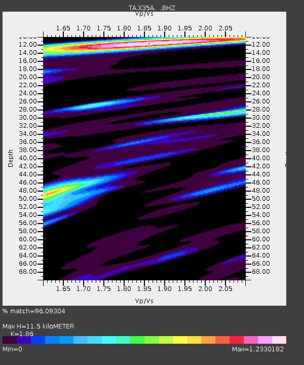
| Estimated Moho Depth: |
11.5 km |
| Estimated Crust Vp/Vs: |
1.86 |
| Assumed Crust Vp: |
6.426 km/s |
| Estimated Crust Vs: |
3.455 km/s |
| Estimated Crust Poisson's Ratio: |
0.30 |
|
| Radial Match: |
96.09304 % |
| Radial Bump: |
391 |
| Transverse Match: |
94.83564 % |
| Transverse Bump: |
388 |
| SOD ConfigId: |
346946 |
| Insert Time: |
2011-07-04 10:02:03.516 +0000 |
| GWidth: |
2.5 |
| Max Bumps: |
400 |
| Tol: |
0.001 |
|
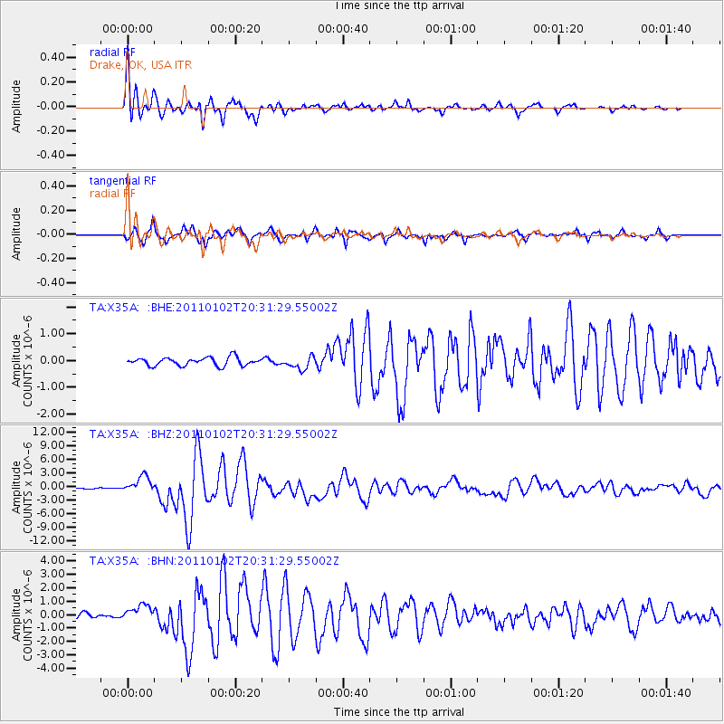
Signal To Noise
| Channel | StoN | STA | LTA |
| TA:X35A: :BHZ:20110102T20:31:29.55002Z | 13.3618355 | 1.8847805E-6 | 1.4105701E-7 |
| TA:X35A: :BHN:20110102T20:31:29.55002Z | 2.639671 | 5.970578E-7 | 2.2618643E-7 |
| TA:X35A: :BHE:20110102T20:31:29.55002Z | 1.5656676 | 2.3561533E-7 | 1.5048873E-7 |
| Arrivals |
| Ps | 1.6 SECOND |
| PpPs | 5.0 SECOND |
| PsPs/PpSs | 6.6 SECOND |


