You are here: Home > Network List > TA - USArray Transportable Network (new EarthScope stations) Stations List
> Station Y37A Hugo, OK, USA > Earthquake Result Viewer
Y37A Hugo, OK, USA - Earthquake Result Viewer
| Earthquake location: |
Near Coast Of Central Chile |
| Earthquake latitude/longitude: |
-38.4/-73.3 |
| Earthquake time(UTC): |
2011/01/02 (002) 20:20:17 GMT |
| Earthquake Depth: |
24 km |
| Earthquake Magnitude: |
6.6 MB, 7.1 MS, 7.1 MW, 7.0 MW |
| Earthquake Catalog/Contributor: |
WHDF/NEIC |
|
| Network: |
TA USArray Transportable Network (new EarthScope stations) |
| Station: |
Y37A Hugo, OK, USA |
| Lat/Lon: |
33.98 N/95.62 W |
| Elevation: |
165 m |
|
| Distance: |
74.9 deg |
| Az: |
340.941 deg |
| Baz: |
162.004 deg |
| Ray Param: |
0.052002616 |
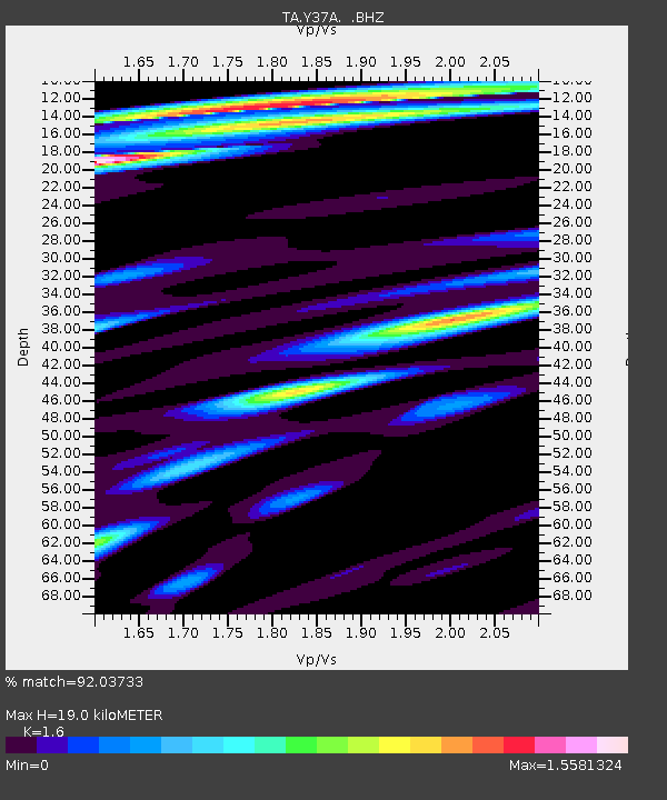
| Estimated Moho Depth: |
19.0 km |
| Estimated Crust Vp/Vs: |
1.60 |
| Assumed Crust Vp: |
6.245 km/s |
| Estimated Crust Vs: |
3.903 km/s |
| Estimated Crust Poisson's Ratio: |
0.18 |
|
| Radial Match: |
92.03733 % |
| Radial Bump: |
400 |
| Transverse Match: |
87.39012 % |
| Transverse Bump: |
400 |
| SOD ConfigId: |
346946 |
| Insert Time: |
2011-07-04 10:05:43.694 +0000 |
| GWidth: |
2.5 |
| Max Bumps: |
400 |
| Tol: |
0.001 |
|

Signal To Noise
| Channel | StoN | STA | LTA |
| TA:Y37A: :BHZ:20110102T20:31:25.225007Z | 12.434816 | 2.2152155E-6 | 1.7814622E-7 |
| TA:Y37A: :BHN:20110102T20:31:25.225007Z | 3.058619 | 8.512378E-7 | 2.783079E-7 |
| TA:Y37A: :BHE:20110102T20:31:25.225007Z | 1.7986662 | 4.0853644E-7 | 2.2713299E-7 |
| Arrivals |
| Ps | 1.9 SECOND |
| PpPs | 7.6 SECOND |
| PsPs/PpSs | 9.5 SECOND |


