You are here: Home > Network List > TA - USArray Transportable Network (new EarthScope stations) Stations List
> Station N35A Tabor, IA, USA > Earthquake Result Viewer
N35A Tabor, IA, USA - Earthquake Result Viewer
| Earthquake location: |
Near Coast Of Central Chile |
| Earthquake latitude/longitude: |
-38.4/-73.3 |
| Earthquake time(UTC): |
2011/01/02 (002) 20:20:17 GMT |
| Earthquake Depth: |
24 km |
| Earthquake Magnitude: |
6.6 MB, 7.1 MS, 7.1 MW, 7.0 MW |
| Earthquake Catalog/Contributor: |
WHDF/NEIC |
|
| Network: |
TA USArray Transportable Network (new EarthScope stations) |
| Station: |
N35A Tabor, IA, USA |
| Lat/Lon: |
40.86 N/95.64 W |
| Elevation: |
353 m |
|
| Distance: |
81.4 deg |
| Az: |
343.067 deg |
| Baz: |
162.428 deg |
| Ray Param: |
0.047561266 |
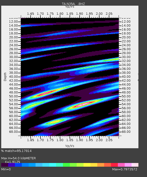
| Estimated Moho Depth: |
54.0 km |
| Estimated Crust Vp/Vs: |
1.91 |
| Assumed Crust Vp: |
6.498 km/s |
| Estimated Crust Vs: |
3.397 km/s |
| Estimated Crust Poisson's Ratio: |
0.31 |
|
| Radial Match: |
95.17814 % |
| Radial Bump: |
400 |
| Transverse Match: |
84.01348 % |
| Transverse Bump: |
400 |
| SOD ConfigId: |
346946 |
| Insert Time: |
2011-07-04 10:08:06.395 +0000 |
| GWidth: |
2.5 |
| Max Bumps: |
400 |
| Tol: |
0.001 |
|
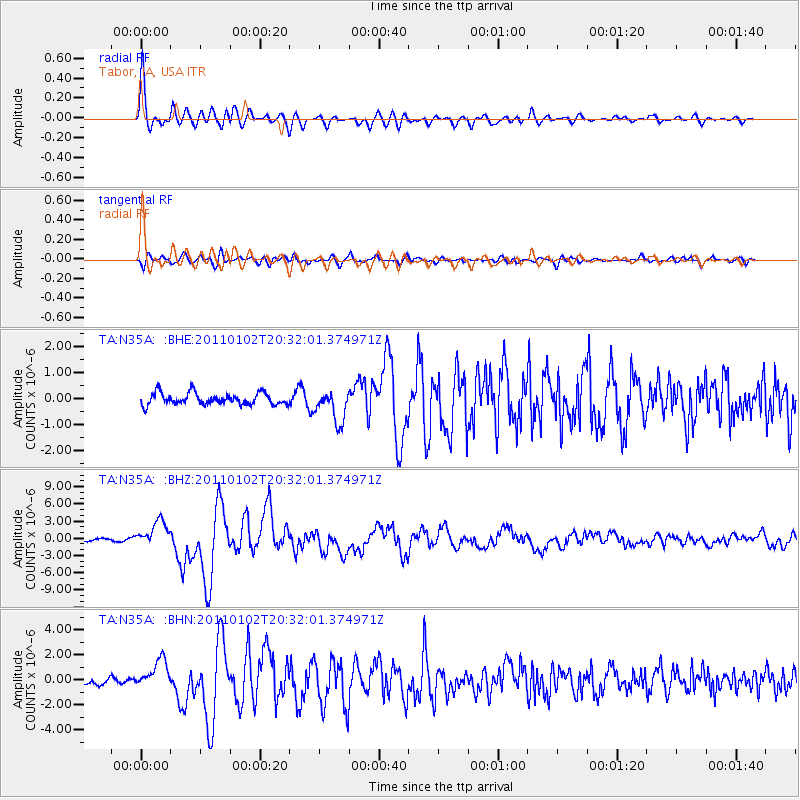
Signal To Noise
| Channel | StoN | STA | LTA |
| TA:N35A: :BHZ:20110102T20:32:01.374971Z | 11.2915325 | 2.2361464E-6 | 1.9803747E-7 |
| TA:N35A: :BHN:20110102T20:32:01.374971Z | 5.418626 | 1.1473429E-6 | 2.1174057E-7 |
| TA:N35A: :BHE:20110102T20:32:01.374971Z | 2.7335377 | 6.115934E-7 | 2.2373695E-7 |
| Arrivals |
| Ps | 7.8 SECOND |
| PpPs | 24 SECOND |
| PsPs/PpSs | 31 SECOND |


