You are here: Home > Network List > TA - USArray Transportable Network (new EarthScope stations) Stations List
> Station 136A Ennis, TX, USA > Earthquake Result Viewer
136A Ennis, TX, USA - Earthquake Result Viewer
| Earthquake location: |
Near Coast Of Central Chile |
| Earthquake latitude/longitude: |
-38.4/-73.3 |
| Earthquake time(UTC): |
2011/01/02 (002) 20:20:17 GMT |
| Earthquake Depth: |
24 km |
| Earthquake Magnitude: |
6.6 MB, 7.1 MS, 7.1 MW, 7.0 MW |
| Earthquake Catalog/Contributor: |
WHDF/NEIC |
|
| Network: |
TA USArray Transportable Network (new EarthScope stations) |
| Station: |
136A Ennis, TX, USA |
| Lat/Lon: |
32.47 N/96.53 W |
| Elevation: |
113 m |
|
| Distance: |
73.7 deg |
| Az: |
339.698 deg |
| Baz: |
161.172 deg |
| Ray Param: |
0.052797403 |
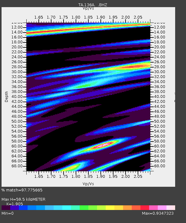
| Estimated Moho Depth: |
59.5 km |
| Estimated Crust Vp/Vs: |
1.90 |
| Assumed Crust Vp: |
6.38 km/s |
| Estimated Crust Vs: |
3.349 km/s |
| Estimated Crust Poisson's Ratio: |
0.31 |
|
| Radial Match: |
97.775665 % |
| Radial Bump: |
354 |
| Transverse Match: |
86.76251 % |
| Transverse Bump: |
400 |
| SOD ConfigId: |
346946 |
| Insert Time: |
2011-07-04 10:10:13.296 +0000 |
| GWidth: |
2.5 |
| Max Bumps: |
400 |
| Tol: |
0.001 |
|

Signal To Noise
| Channel | StoN | STA | LTA |
| TA:136A: :BHZ:20110102T20:31:18.350007Z | 16.301195 | 2.076561E-6 | 1.2738704E-7 |
| TA:136A: :BHN:20110102T20:31:18.350007Z | 3.81691 | 7.523867E-7 | 1.9711932E-7 |
| TA:136A: :BHE:20110102T20:31:18.350007Z | 1.3315423 | 3.4181807E-7 | 2.567084E-7 |
| Arrivals |
| Ps | 8.7 SECOND |
| PpPs | 26 SECOND |
| PsPs/PpSs | 35 SECOND |


