You are here: Home > Network List > TA - USArray Transportable Network (new EarthScope stations) Stations List
> Station X38A Whitesboro, OK, USA > Earthquake Result Viewer
X38A Whitesboro, OK, USA - Earthquake Result Viewer
| Earthquake location: |
Near Coast Of Central Chile |
| Earthquake latitude/longitude: |
-38.4/-73.3 |
| Earthquake time(UTC): |
2011/01/02 (002) 20:20:17 GMT |
| Earthquake Depth: |
24 km |
| Earthquake Magnitude: |
6.6 MB, 7.1 MS, 7.1 MW, 7.0 MW |
| Earthquake Catalog/Contributor: |
WHDF/NEIC |
|
| Network: |
TA USArray Transportable Network (new EarthScope stations) |
| Station: |
X38A Whitesboro, OK, USA |
| Lat/Lon: |
34.67 N/94.83 W |
| Elevation: |
234 m |
|
| Distance: |
75.3 deg |
| Az: |
341.803 deg |
| Baz: |
162.67 deg |
| Ray Param: |
0.05170357 |
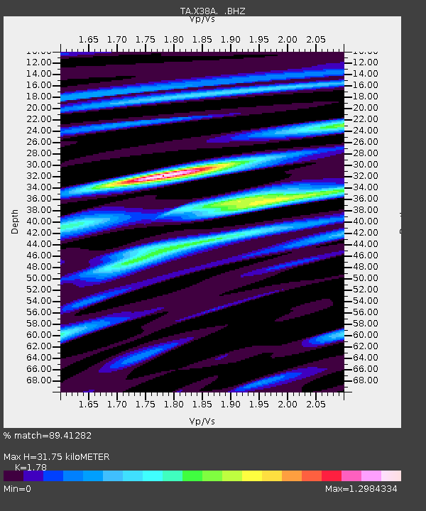
| Estimated Moho Depth: |
31.75 km |
| Estimated Crust Vp/Vs: |
1.78 |
| Assumed Crust Vp: |
6.498 km/s |
| Estimated Crust Vs: |
3.65 km/s |
| Estimated Crust Poisson's Ratio: |
0.27 |
|
| Radial Match: |
89.41282 % |
| Radial Bump: |
396 |
| Transverse Match: |
90.65871 % |
| Transverse Bump: |
400 |
| SOD ConfigId: |
346946 |
| Insert Time: |
2011-07-04 10:10:53.998 +0000 |
| GWidth: |
2.5 |
| Max Bumps: |
400 |
| Tol: |
0.001 |
|

Signal To Noise
| Channel | StoN | STA | LTA |
| TA:X38A: :BHZ:20110102T20:31:27.850007Z | 5.716903 | 2.2352685E-6 | 3.9099288E-7 |
| TA:X38A: :BHN:20110102T20:31:27.850007Z | 2.25565 | 8.7464207E-7 | 3.877561E-7 |
| TA:X38A: :BHE:20110102T20:31:27.850007Z | 0.7795421 | 2.9843477E-7 | 3.8283346E-7 |
| Arrivals |
| Ps | 3.9 SECOND |
| PpPs | 13 SECOND |
| PsPs/PpSs | 17 SECOND |


