You are here: Home > Network List > TA - USArray Transportable Network (new EarthScope stations) Stations List
> Station V38A Canehill, AR, USA > Earthquake Result Viewer
V38A Canehill, AR, USA - Earthquake Result Viewer

| Earthquake location: |
Near Coast Of Central Chile |
| Earthquake latitude/longitude: |
-38.4/-73.3 |
| Earthquake time(UTC): |
2011/01/02 (002) 20:20:17 GMT |
| Earthquake Depth: |
24 km |
| Earthquake Magnitude: |
6.6 MB, 7.1 MS, 7.1 MW, 7.0 MW |
| Earthquake Catalog/Contributor: |
WHDF/NEIC |
|
| Network: |
TA USArray Transportable Network (new EarthScope stations) |
| Station: |
V38A Canehill, AR, USA |
| Lat/Lon: |
35.86 N/94.41 W |
| Elevation: |
372 m |
|
| Distance: |
76.4 deg |
| Az: |
342.505 deg |
| Baz: |
163.084 deg |
| Ray Param: |
0.051004358 |
| Estimated Moho Depth: |
44.5 km |
| Estimated Crust Vp/Vs: |
1.77 |
| Assumed Crust Vp: |
6.498 km/s |
| Estimated Crust Vs: |
3.676 km/s |
| Estimated Crust Poisson's Ratio: |
0.26 |
|
| Radial Match: |
94.270004 % |
| Radial Bump: |
400 |
| Transverse Match: |
83.72068 % |
| Transverse Bump: |
400 |
| SOD ConfigId: |
346946 |
| Insert Time: |
2011-07-04 10:11:37.934 +0000 |
| GWidth: |
2.5 |
| Max Bumps: |
400 |
| Tol: |
0.001 |
|
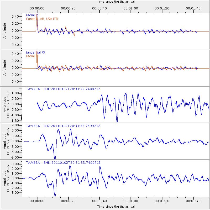
Signal To Noise
| Channel | StoN | STA | LTA |
| TA:V38A: :BHZ:20110102T20:31:33.749971Z | 12.789102 | 2.2708612E-6 | 1.775622E-7 |
| TA:V38A: :BHN:20110102T20:31:33.749971Z | 5.2856493 | 7.695631E-7 | 1.4559481E-7 |
| TA:V38A: :BHE:20110102T20:31:33.749971Z | 1.3835375 | 2.8852065E-7 | 2.0853837E-7 |
| Arrivals |
| Ps | 5.4 SECOND |
| PpPs | 18 SECOND |
| PsPs/PpSs | 24 SECOND |


