You are here: Home > Network List > TA - USArray Transportable Network (new EarthScope stations) Stations List
> Station U35A Pawnee, OK, USA > Earthquake Result Viewer
U35A Pawnee, OK, USA - Earthquake Result Viewer

| Earthquake location: |
Near Coast Of Central Chile |
| Earthquake latitude/longitude: |
-38.4/-73.3 |
| Earthquake time(UTC): |
2011/01/02 (002) 20:20:17 GMT |
| Earthquake Depth: |
24 km |
| Earthquake Magnitude: |
6.6 MB, 7.1 MS, 7.1 MW, 7.0 MW |
| Earthquake Catalog/Contributor: |
WHDF/NEIC |
|
| Network: |
TA USArray Transportable Network (new EarthScope stations) |
| Station: |
U35A Pawnee, OK, USA |
| Lat/Lon: |
36.37 N/96.73 W |
| Elevation: |
303 m |
|
| Distance: |
77.4 deg |
| Az: |
340.824 deg |
| Baz: |
161.339 deg |
| Ray Param: |
0.050293908 |
| Estimated Moho Depth: |
39.75 km |
| Estimated Crust Vp/Vs: |
1.90 |
| Assumed Crust Vp: |
6.483 km/s |
| Estimated Crust Vs: |
3.412 km/s |
| Estimated Crust Poisson's Ratio: |
0.31 |
|
| Radial Match: |
96.809204 % |
| Radial Bump: |
223 |
| Transverse Match: |
93.68091 % |
| Transverse Bump: |
400 |
| SOD ConfigId: |
346946 |
| Insert Time: |
2011-07-04 10:12:31.624 +0000 |
| GWidth: |
2.5 |
| Max Bumps: |
400 |
| Tol: |
0.001 |
|
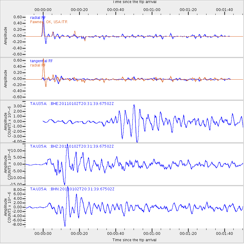
Signal To Noise
| Channel | StoN | STA | LTA |
| TA:U35A: :BHZ:20110102T20:31:39.67502Z | 10.027419 | 2.2818429E-6 | 2.2756034E-7 |
| TA:U35A: :BHN:20110102T20:31:39.67502Z | 5.7179303 | 1.034692E-6 | 1.8095567E-7 |
| TA:U35A: :BHE:20110102T20:31:39.67502Z | 1.8689173 | 3.7731198E-7 | 2.01888E-7 |
| Arrivals |
| Ps | 5.7 SECOND |
| PpPs | 17 SECOND |
| PsPs/PpSs | 23 SECOND |


