You are here: Home > Network List > TA - USArray Transportable Network (new EarthScope stations) Stations List
> Station U36A Oologah, OK, USA > Earthquake Result Viewer
U36A Oologah, OK, USA - Earthquake Result Viewer
| Earthquake location: |
Near Coast Of Central Chile |
| Earthquake latitude/longitude: |
-38.4/-73.3 |
| Earthquake time(UTC): |
2011/01/02 (002) 20:20:17 GMT |
| Earthquake Depth: |
24 km |
| Earthquake Magnitude: |
6.6 MB, 7.1 MS, 7.1 MW, 7.0 MW |
| Earthquake Catalog/Contributor: |
WHDF/NEIC |
|
| Network: |
TA USArray Transportable Network (new EarthScope stations) |
| Station: |
U36A Oologah, OK, USA |
| Lat/Lon: |
36.39 N/95.73 W |
| Elevation: |
187 m |
|
| Distance: |
77.2 deg |
| Az: |
341.616 deg |
| Baz: |
162.103 deg |
| Ray Param: |
0.050451234 |
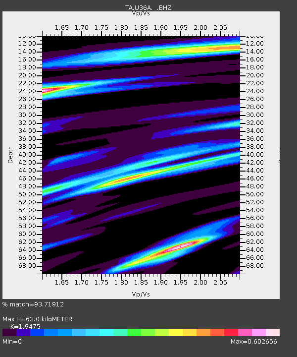
| Estimated Moho Depth: |
63.0 km |
| Estimated Crust Vp/Vs: |
1.95 |
| Assumed Crust Vp: |
6.53 km/s |
| Estimated Crust Vs: |
3.353 km/s |
| Estimated Crust Poisson's Ratio: |
0.32 |
|
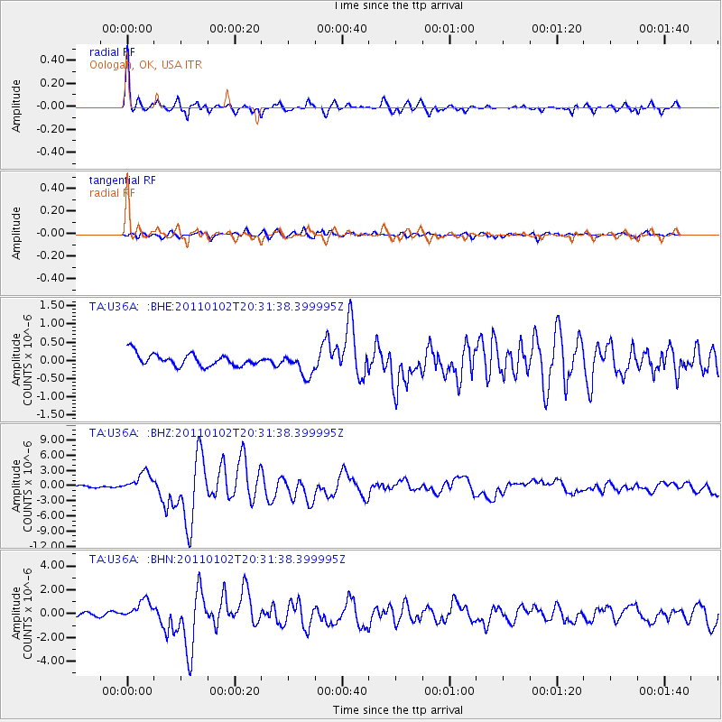
| Radial Match: |
93.71912 % |
| Radial Bump: |
400 |
| Transverse Match: |
80.470604 % |
| Transverse Bump: |
400 |
| SOD ConfigId: |
346946 |
| Insert Time: |
2011-07-04 10:12:53.719 +0000 |
| GWidth: |
2.5 |
| Max Bumps: |
400 |
| Tol: |
0.001 |
|
Signal To Noise
| Channel | StoN | STA | LTA |
| TA:U36A: :BHZ:20110102T20:31:38.399995Z | 6.281689 | 2.0158436E-6 | 3.2090787E-7 |
| TA:U36A: :BHN:20110102T20:31:38.399995Z | 4.1811566 | 8.397574E-7 | 2.0084333E-7 |
| TA:U36A: :BHE:20110102T20:31:38.399995Z | 1.9031236 | 3.175502E-7 | 1.6685736E-7 |
| Arrivals |
| Ps | 9.4 SECOND |
| PpPs | 28 SECOND |
| PsPs/PpSs | 37 SECOND |


