You are here: Home > Network List > TA - USArray Transportable Network (new EarthScope stations) Stations List
> Station C33A Trail, MN, USA > Earthquake Result Viewer
C33A Trail, MN, USA - Earthquake Result Viewer
| Earthquake location: |
Near Coast Of Central Chile |
| Earthquake latitude/longitude: |
-38.4/-73.3 |
| Earthquake time(UTC): |
2011/01/02 (002) 20:20:17 GMT |
| Earthquake Depth: |
24 km |
| Earthquake Magnitude: |
6.6 MB, 7.1 MS, 7.1 MW, 7.0 MW |
| Earthquake Catalog/Contributor: |
WHDF/NEIC |
|
| Network: |
TA USArray Transportable Network (new EarthScope stations) |
| Station: |
C33A Trail, MN, USA |
| Lat/Lon: |
47.76 N/95.77 W |
| Elevation: |
388 m |
|
| Distance: |
88.0 deg |
| Az: |
345.062 deg |
| Baz: |
162.521 deg |
| Ray Param: |
0.04285653 |
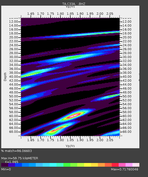
| Estimated Moho Depth: |
59.75 km |
| Estimated Crust Vp/Vs: |
1.87 |
| Assumed Crust Vp: |
6.419 km/s |
| Estimated Crust Vs: |
3.442 km/s |
| Estimated Crust Poisson's Ratio: |
0.30 |
|
| Radial Match: |
96.06683 % |
| Radial Bump: |
146 |
| Transverse Match: |
83.48895 % |
| Transverse Bump: |
263 |
| SOD ConfigId: |
346946 |
| Insert Time: |
2011-07-04 10:21:44.994 +0000 |
| GWidth: |
2.5 |
| Max Bumps: |
400 |
| Tol: |
0.001 |
|
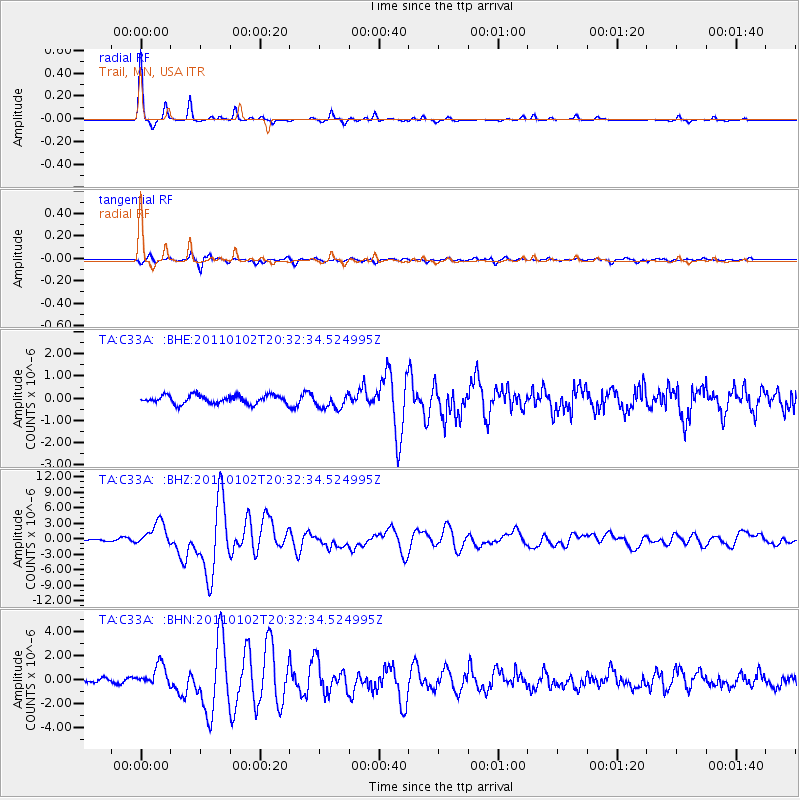
Signal To Noise
| Channel | StoN | STA | LTA |
| TA:C33A: :BHZ:20110102T20:32:34.524995Z | 19.771212 | 2.3282328E-6 | 1.1775874E-7 |
| TA:C33A: :BHN:20110102T20:32:34.524995Z | 3.2905357 | 9.0205236E-7 | 2.741354E-7 |
| TA:C33A: :BHE:20110102T20:32:34.524995Z | 1.7692212 | 3.3605477E-7 | 1.8994504E-7 |
| Arrivals |
| Ps | 8.2 SECOND |
| PpPs | 26 SECOND |
| PsPs/PpSs | 34 SECOND |


