You are here: Home > Network List > TA - USArray Transportable Network (new EarthScope stations) Stations List
> Station G32A Webster, SD, USA > Earthquake Result Viewer
G32A Webster, SD, USA - Earthquake Result Viewer
| Earthquake location: |
Near Coast Of Central Chile |
| Earthquake latitude/longitude: |
-38.4/-73.3 |
| Earthquake time(UTC): |
2011/01/02 (002) 20:20:17 GMT |
| Earthquake Depth: |
24 km |
| Earthquake Magnitude: |
6.6 MB, 7.1 MS, 7.1 MW, 7.0 MW |
| Earthquake Catalog/Contributor: |
WHDF/NEIC |
|
| Network: |
TA USArray Transportable Network (new EarthScope stations) |
| Station: |
G32A Webster, SD, USA |
| Lat/Lon: |
45.26 N/97.50 W |
| Elevation: |
566 m |
|
| Distance: |
86.0 deg |
| Az: |
343.146 deg |
| Baz: |
161.172 deg |
| Ray Param: |
0.04431417 |
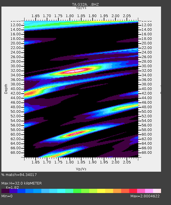
| Estimated Moho Depth: |
32.0 km |
| Estimated Crust Vp/Vs: |
1.82 |
| Assumed Crust Vp: |
6.552 km/s |
| Estimated Crust Vs: |
3.6 km/s |
| Estimated Crust Poisson's Ratio: |
0.28 |
|
| Radial Match: |
94.34017 % |
| Radial Bump: |
389 |
| Transverse Match: |
87.651924 % |
| Transverse Bump: |
323 |
| SOD ConfigId: |
346946 |
| Insert Time: |
2011-07-04 10:23:56.712 +0000 |
| GWidth: |
2.5 |
| Max Bumps: |
400 |
| Tol: |
0.001 |
|
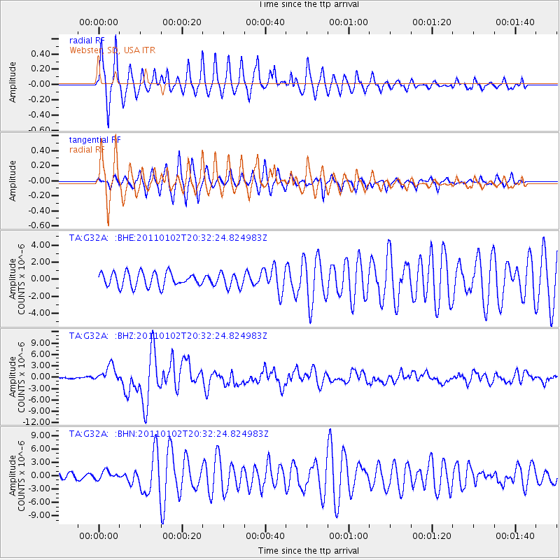
Signal To Noise
| Channel | StoN | STA | LTA |
| TA:G32A: :BHZ:20110102T20:32:24.824983Z | 12.966615 | 2.2491852E-6 | 1.7345971E-7 |
| TA:G32A: :BHN:20110102T20:32:24.824983Z | 1.3750341 | 9.2785484E-7 | 6.747868E-7 |
| TA:G32A: :BHE:20110102T20:32:24.824983Z | 1.0319859 | 8.3793685E-7 | 8.1196544E-7 |
| Arrivals |
| Ps | 4.1 SECOND |
| PpPs | 13 SECOND |
| PsPs/PpSs | 18 SECOND |


